
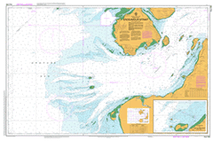
AUS 294
Endeavour Strait
Please note that all charts are nominally folded in half for storage and handling as per the marine industries standard.
If you require an unfolded copy (ie: flat for framing), please select Flat Paper, and we will organise a special print service to accomodate your request.
Description
This official Nautical Chart is produced by the Australian Hydrographic Office, and corrected fortnightly to 'Notice to Marines' by Cairns Charts & Maps. This ensures it remains compliance with Safety of Navigation requirements. This marine chart, or 'sea map', is primarily produced to support the safe navigation of commercial shipping through Australian, Papua New Guinea and Solomon Island waters.
Nautical charts depict the seabed, or bathymetry, using a variety of colours to shade the depth regions. Darker blues indicate shallower water, while light blues and white indicate deeper water. A chart will also show continuous contour lines (at varying intervals depending on the scale of the chart), 'spot depths' across the whole area, as well as different symbols indicating wrecks, shallow rocks and dangers, as well as details on lights, light houses, tides and currents.
For extensive detail on the symbology of nautical charts, the Symbols and Abbreviations used on Admiralty Charts is the definitive reference.
Bamaga New Mapoon Umagico Injinoo Aloa Asp Shoals Bampfield Head Barn Island Biffin Creek Big Buttertin Beach Boat Channel Booby Island Brady Banks Burster Creek Cheropo Island Cody Creek Cody Hill Cape Cornwall Cowal Cowal Creek Crab Island Dayman Island Dumaralug Island Eagle Rock Endeavour Strait Entrance Island Galloways Hill Gerard Bank Gibson Rock Great Woody Island Heroine Rock Herring Creek High Island Hochepied Head Horn Island Ichera Head Inskip Banks Jardine River Jardine Rock Karniga Island Laradeenya Creek Larpent Bank Port Lihou Little Beach Little Roko Island Little Woody Island Loggan Creek Long Beach Markilug Islet Marou Creek Meddler Island Mission Hill Mosby Creek Mouinndo Islet Muralug Mutee Head Nona Creek North West Islet Packe Island Papou Point Paterson Creek Mount Paterson Peak Hill Peak Point Peebles Shoals Port Lihou Island Possession Island Prince of Wales Island Pym Point Quoin Island Rattlesnake Point Red Banks Red Island Red Island Point Red Point Red Wallis Island Roko Island Rothsay Banks Seisia Sherard Osborn Point Simpson Bay Slade Slade Point Smith Point Smyth Creek Somerset Spring Creek Sunshine Point Terry Beach The Jardine Swamps Tuluaa Islet Turtle Island Van Spoult Head Wallis Banks Wilson Creek Woody Wallis Island Wuwurrka Islet Yule Point Possession Island National Park Punsand Prince of Wales Horn Double Hill Greenant Hill Narupai The Gut Bogan Banks Bold Hill Friday Passage Garagar Point Big Woody Island Kai-Yelubi Island Bampfield Quion Island Meggi-Yelubi Island Peaked Hill Carubaura Despair Djuna Bedanug Roonga Point Tarilug Point Lihou Point Libou Wassel Island Wuwurrka Island Markilug Island Otuckano Creek Peebles Shoal Paterson Hill Mouinndo Rock Parau Island Jamunnda Red Wallis Islet Cowal Creek Mission Station Van Speult Point Mutee Mission Mutee Mission Station Ichera Point Black Gin Creek Jardine Swamps