
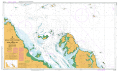
AUS 260
Broad Sound Channel And Shoalwater Bay
Please note that all charts are nominally folded in half for storage and handling as per the marine industries standard.
If you require an unfolded copy (ie: flat for framing), please select Flat Paper, and we will organise a special print service to accomodate your request.
Description
This official Nautical Chart is produced by the Australian Hydrographic Office, and corrected fortnightly to 'Notice to Marines' by Cairns Charts & Maps. This ensures it remains compliance with Safety of Navigation requirements. This marine chart, or 'sea map', is primarily produced to support the safe navigation of commercial shipping through Australian, Papua New Guinea and Solomon Island waters.
Nautical charts depict the seabed, or bathymetry, using a variety of colours to shade the depth regions. Darker blues indicate shallower water, while light blues and white indicate deeper water. A chart will also show continuous contour lines (at varying intervals depending on the scale of the chart), 'spot depths' across the whole area, as well as different symbols indicating wrecks, shallow rocks and dangers, as well as details on lights, light houses, tides and currents.
For extensive detail on the symbology of nautical charts, the Symbols and Abbreviations used on Admiralty Charts is the definitive reference.
Townshend Island Stanage Bay Couti Uti Pine Mountain Waratah Akens Island Alnwick Island Annie Island Arthur Point Bay Island Blind Rock Broad Sound Channel Broome Head Brown Rock Bryant Rock Campbell Peak Cannibal Group Canoe Passage Cape Island Charcoal Creek Cheviot Island Clara Group Clara Island Collins Island Connor Rock Corisande Hills Couti Uti Creek Mount Couti Uti Crane Island Danger Island Danger Shoal Dome Island Donovan Shoal Dove Point Earl Banks East Ridge Banks Edward Island Eliza Island Five Trees Cay Harrison Island Hervey Islands Hexham Island Hollins Creek Holt Island Island Head Island Head Creek Jessie Lagoons Jessie Peak Krankeet Mountain Leake Rock Leicester Island Lingham Island Low Island Macdonald Point Marquis Island Master Rocks Mooly Creek Moonlight Creek Mountain Creek Mumford Island Norberry Creek North Channel North Rock North West Channel Notch Mountain Osborn Island Otterbourne Island Parker Creek Passage Patch Payne Shoal Pearl Bay Pelican Rock Peninsula Peninsula Flats Peninsula Range Pier Head Pine Mountain Creek Pinetrees Point Porter Creek Raynham Island Reef Point Ripple Island Rocky Creek Roger Hills Ross Creek Rothbury Island Round Rock Round Rock Ledges Sabina Point Separation Banks Shoalwater Bay Skull Islands Spencer Creek Split Island Stanage Stanage Point Steep Island Strong Tide Passage Sun Island Sunset Rock Supply Bay Swan Island Table Rock Ten Pin Rock Torilla Torilla Hill Townshend Cape Townshend Triangular Island Turn Shoal Tweed Island Two Round Rocks Wadallah Creek West Bight Mount Westall White Rocks White Shoal Shoalwater Bay Conservation Park Low Islet Lucy Ravel Point Stannage Bay Bald Hill Jessie Lagoon Cape Townsend Cape Islet Ripple Islands Cannibal Islands The Shacks Annie Islet Mount Townshend Eliza Islet Rogers Hills Separation Bank The Hollins Edward Islet Sun Islet Mount Couti Outi Bay Islet Couti Outi Triangular Islands Spit Island Wadelah Creek Rose Creek Peninsular Range Coonyan Creek Seventeen Mile Creek