
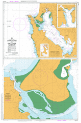
AUS 177
Approaches To Macquarie Harbour
Please note that all charts are nominally folded in half for storage and handling as per the marine industries standard.
If you require an unfolded copy (ie: flat for framing), please select Flat Paper, and we will organise a special print service to accomodate your request.
Description
This official Nautical Chart is produced by the Australian Hydrographic Office, and corrected fortnightly to 'Notice to Marines' by Cairns Charts & Maps. This ensures it remains compliance with Safety of Navigation requirements. This marine chart, or 'sea map', is primarily produced to support the safe navigation of commercial shipping through Australian, Papua New Guinea and Solomon Island waters.
Nautical charts depict the seabed, or bathymetry, using a variety of colours to shade the depth regions. Darker blues indicate shallower water, while light blues and white indicate deeper water. A chart will also show continuous contour lines (at varying intervals depending on the scale of the chart), 'spot depths' across the whole area, as well as different symbols indicating wrecks, shallow rocks and dangers, as well as details on lights, light houses, tides and currents.
For extensive detail on the symbology of nautical charts, the Symbols and Abbreviations used on Admiralty Charts is the definitive reference.
Strahan Albina Creek Albina Rock Alma Point Double Cove Dunes Creek Asbestos Point Back Channel Backagain Point Baylee Creek Beehive Creek Betsys Bay Big Pebbly Beach Birchs Beach Birchs Narrows Bird Islets Birthday Bay Blackwood Creek Bonnet Bay Bonnet Island Botanical Creek Bowra Rock Braddon Point Braddon River Briggs Creek Brisbanes Bay Bryans Bay Buoy Point Butler Creek Butt Of Liberty Camp Point Camp Spur Cape Sorell Cape Sorell Historic Site Cape Sorell Lighthouse Cat Island Channel Bay Channel Hill Charcoal Burners Bluff Charleys Beach Clark River Cliff Spur Coal Head Connellys Point Connellys Point Creek Cosy Corner Cradle Creek Crown Spur Cutten Creek Darktown Bay Dart Point Davis Bay Dead Horse Point Defriez Bay Dingy Point Discovery Beach Edwards Bay Elizabeth Island Entrance Island Entrance Rock Farm Cove Farm Cove Game Reserve Flannigans Creek Flannigans Flat Fleabite Creek Four Mile Creek Fouscha Creek Fraser Flats Grandfathers Beach Gravelly Creek Garfield River Goat Hill Gordon Lagoon Gordon Point Gorge Creek Gorge Point Gorings Creek Gould Point Grubbys Point Grummet Island Hallidays Island Halls Creek Hannants Bight Harpers Hill Harveys Creek Hawks Nest Cove Hazel Creek Hells Gates Henrietta Creek Henry Point Heron Pond Hogan Cove Hogarth Falls Horsetrough Creek Hospital Creek Iron Creek John Butters Power Station Karitane Rock Kawatiri Shoal Kelly Basin Kelly Channel Kelly Gully Kelly Hill Kidney Cove King Point King River Kingfisher Creek Lagoon Creek Lake Koonya Lake Strahan Lettes Bay Liberty Bay Liberty Creek Liberty Point Lignite Creek Lilaree Creek Long Bay Lowana Point Lower Landing Creek Lucas Creek Lucas Point Lucky Creek Macquarie Harbour Macquarie Harbour Historic Site Macquarie Heads Macquarie Heads Camping Ground Magazine Island Magazine Point Magazine Point Conservation Area Mill Bay Minx Point Morse Bay Mosquito Cove Mount Antill Mount Lyell Railway Mount Obvious Mount Sorell Mount Strahan Muddy Cove Muddy Cove Creek Murderers Beach Napier Hills Neck Island Newall Creek Newall Spur Nielsen River Nigger Head Noddy Creek Ocean Beach Olsen Reef Open Creek Pebbly Beach Peevers Creek Pelias Cove Pelican Spit Peoples Park Philips Island Piccaninny Point Picnic Point Pillinger Pilot Bay Pilot Beach Pine Corner Pine Cove Pine Cove Creek Pine Cove Point Pine Point Porteus Creek Prater Rock Purdys Creek Quail Creek Queen River Regatta Point Richardsons Bay Rinadeena Saddle Risby Cove River Point Round Head Rum Point Sailor Jack Creek Sarah Island Schofield Creek Sea Reach Shag Islands Shamrock Point Signal Point Skeeter Creek Slate Spur Sloop Point Smith Cove Soldiers Island Sophia Point Split Rock Spur Point St Leger Point Starting Creek Steadman Beach Steadman Point Strahan Aerodrome Strahan Customs House Historic Site Strahan Golf Course Strahan Harbour Strahan Point Sulphide Creek Surging Point Swan Basin Swan Basin Picnic Ground Swan Basin Plantation Swift Creek Table Creek Table Head Teal Pond Teepookana The Cap The Grandfathers Thomas Currie Rivulet Tiddys Beach Tidegauge Rock Timms Eddy Tinkers Rock Tonys Creek Trumpeter Point Trumpeter Rock Tuan Gabby Flats Turners Rock Virginia Creek Waller Creek War Memorial Park Water Tower Hill Waterfall Gully Watts Hill Wellington Head West Coast Range Regional Reserve West Strahan West Strahan Beach Whale Rock Winding Creek Wooding Point Woody Hill Wrights Bay Yellow Bluff Yolla Point Bell Hill Big Gravelly Beach Bird Island Bobs Bay Braddon Bay Centre Hill Gate Hill Landing Creek Long Reach Lowana Manuka Creek Bridge Murderers Cave Nugents Bay Old Strahan Outer Bay Rinadeena Rock Island Sloop Rocks Stella Siding Store Island Teepookana Forest Reserve The Dock Twin Islands Stella Manuka Creek Newell Creek Currie River Lette Bay Teepookana Siding Starling Creek Cape Sorrell Bonnet Islet Shag Island Betsey Island Betsy Island Mount Sorrell Philip Island Settlement Island Gordon River Big Creek Barnes Creek Birthday Creek Birch Inlet Birches Inlet