
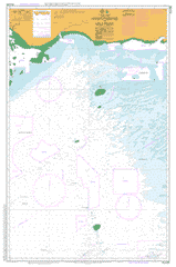
AUS 842
Varzin Passage To Unji Point
Please note that all charts are nominally folded in half for storage and handling as per the marine industries standard.
If you require an unfolded copy (ie: flat for framing), please select Flat Paper, and we will organise a special print service to accomodate your request.
Description
This official Nautical Chart is produced by the Australian Hydrographic Office, and corrected fortnightly to 'Notice to Marines' by Cairns Charts & Maps. This ensures it remains compliance with Safety of Navigation requirements. This marine chart, or 'sea map', is primarily produced to support the safe navigation of commercial shipping through Australian, Papua New Guinea and Solomon Island waters.
Nautical charts depict the seabed, or bathymetry, using a variety of colours to shade the depth regions. Darker blues indicate shallower water, while light blues and white indicate deeper water.A chart will also show continuous contour lines (at varying intervals depending on the scale of the chart), 'spot depths' across the whole area, as well as different symbols indicating wrecks, shallow rocks and dangers, as well as details on lights, light houses, tides and currents.
For extensive detail on the symbology of nautical charts, the Symbols and Abbreviations used on Admiralty Charts is the definitive reference.
Bramble Patches Cook Reef Cook Shoal Deliverance Island Duncan Fantome Reef Glamis Castle Shoal Kerr Islet Merkara Shoal Proudfoot Shoal Sketty Belle Shoal Swan Shoal Turu Cay Varzin Passage Varzin Shoal Kerr Tura Cay Yobu Point Yabu Point Wurado Point Walater Point Walarter Point Watarter Point Thompson Bay Thomson Bay Tarudaru Point Parliament Point Tais Morehead River Tatogabe Mari Mare Maguara Point Naguara Point Jarai Bay Gerai Bay Jerai Bay Jarai Jara Heath Bay Health Bay Galital Point Bula Bulla Marin Murin Bensbach River Bensback River Bensbak River Torassi River Shoalwater Point Glamis Castle Morehead MHY Mavlok