
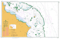
AUS 832
Cape Flattery To Barrow Point
Please note that all charts are nominally folded in half for storage and handling as per the marine industries standard.
If you require an unfolded copy (ie: flat for framing), please select Flat Paper, and we will organise a special print service to accomodate your request.
Description
This official Nautical Chart is produced by the Australian Hydrographic Office, and corrected fortnightly to 'Notice to Marines' by Cairns Charts & Maps. This ensures it remains compliance with Safety of Navigation requirements. This marine chart, or 'sea map', is primarily produced to support the safe navigation of commercial shipping through Australian, Papua New Guinea and Solomon Island waters.
Nautical charts depict the seabed, or bathymetry, using a variety of colours to shade the depth regions. Darker blues indicate shallower water, while light blues and white indicate deeper water.A chart will also show continuous contour lines (at varying intervals depending on the scale of the chart), 'spot depths' across the whole area, as well as different symbols indicating wrecks, shallow rocks and dangers, as well as details on lights, light houses, tides and currents.
For extensive detail on the symbology of nautical charts, the Symbols and Abbreviations used on Admiralty Charts is the definitive reference.
Munburra Starcke Mount Webb Glenrock Elderslie Ada Bank Altanmoui Range Audaer Range Mount Baird Bald Hill Barneys Lake Baron Reef South Barrow Island Barrow Point Beabey Hill Beanley Island Mount Beardmore Beatrice Reef Cape Bedford Beor Reef Bewick Island Bitwon Blackwater Creek Cape Bowen Bridge Creek Brown Peak Cahir Carter Reef Casuarina Hill Cocoa Creek Coconut Island Cole Islands Combe Island Combe Reef Cone Peak Conical Rock Mount Cookabar Cooks Passage Coomban Creek Coquet Island Cormorant Pass Cowton Crescent Reef Crompton Shoals Mount Dardardle Davy Patches Day Reef Decapolis Reef Deception Creek Discovery Eagle Island Eumangin Creek Expectation Creek Eye Reef Eyrie Reef Flat Hill Flattery Flattery Harbour Cape Flattery Fly Reef Forrester Reef Mount Gargaal Mount Gargalee Gorge Creek Grey Hill Gubbins Range Gull Reef Gunga Shoal Half Mile Opening Hampton Island Harrier Reef Helsdon Reef Hicks Reef High Rock Hilder Reef Houghton Island Howick Howick Group Howick Island Howick River Humbug Creek Hummock Creek Hummocks Ingram Island Jaboolego Falls Mount Jack Jeannie River Jewell Reef K Tree Gully Kedge Reef Lakefield Lark Passage Leggatt Island Linnet Reef Lizard Island Lizard Island National Park Long Reef Point Lookout Low Wooded Island Lythe Macgillivray Reef Mackay Reefs Marbogan Falls Martin Reef Marx Reef McIvor McIvor River Megaera Reef Melsonby Melville Mid Reef Miles Reef Morgan River Mount Morgan Morris Island Munro Reef Murdoch Murdoch Island Murdoch Point Murray Reefs Newton Island Ninian Bay Noble Island Mount Norkwa North Channel North Direction Island North Sand Hill Number Ten Patches Nymph Island Old Creek One And A Half Mile Opening One Mile Opening Palfrey Island Pandanus Creek Mount Panielwego Parke Reef Pasco Reef Pethebridge Islets Petricola Shoal Petty Patch Police Creek Pryde Pryde Creek Mount Ray Red Hill Red Point Ribbon Number Eight Reef Ribbon Number Nine Reef Ribbon Number Seven Reef Ribbon Number Ten Reef Rocky Rocky Creek Rocky Islets Rocky Islets National Park Round Hill Running Saddle Hill Saltwater Creek Sand Islet Sandy Creek Seabird Islet Sim Reef Sinclair Island Smith Creek Snake Creek Snake Reef South Island South Bay Point South Direction Island Munburra Resources Reserve Nymph Island National Park Stapleton Island Starcke River Startle Reefs Stewart Shoal Strickland Reef Mount Stuckey Mount Sumbailbe Switzer Reef Tamulan Creek Tayeto Temple Creek Three Islands Tiger Creek Tribulation Creek Tupia Turtle Group Turtle Group National Park Turtle Reef Two Islands Two Islands National Park Two Mile Opening Ulabokal Creek Underwood Shoal Unison Reef Waining Reef Wakooka Wakooka Creek Watson Island Weigall Reefs Welbury White Sand Hill White Water Creek Wika Wilson Rock Wooden Patch Wormboo Yamba Creek Yonge Reef Howick Group National Park Mount Webb National Park Starcke National Park Three Islands National Park North Barrow Island Jack River National Park Melsonby Gaarraay National Park Hope Vale Hope Vale Shire Hope Vale Cook Shire Lizard Temple Hill Nares Hill Yew Reef Monro Reef Tea Reef Stapleton Islet Barrow Islands Barrow Islets Sand Hills Abbey Peak Mission Combe Islet Coombe Island Ingram Islet Coombe Reef Beanley Islet Park Reef One and a Half Mile Opening Warson Island Howick Group Island Wurkuldi Sand Island Megaera Rock Wulumoi Mac Gillivray Reef En Island Cormorant Passage Lizard Island Resort Covered Reef Eagle Islet Newt South Islet Seabird Island Kew Islands Pethebridge Islands Maxwell Reef Em Reef Ell Reef Ribbon Reef Nares Reef Starke Outstation Mount Gangalee Lookout Point Sand Hill Four Foot Rock White Sand Hills Twelve Mile Yards Mount Numbargulme Aitch Reef Tilbrook Bank Tillbrook Bank Gee Reef Two Isles Low Wooded Isle Low Woody Island Finger Three Isles McIvor River Mission McIvor River Mission Station Lark Pass Cocoanut Island Ef Reef Dundee Divide