
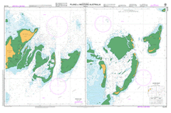
AUS 83
Plans In Western Australia (Sheet 5)
Please note that all charts are nominally folded in half for storage and handling as per the marine industries standard.
If you require an unfolded copy (ie: flat for framing), please select Flat Paper, and we will organise a special print service to accomodate your request.
Description
This official Nautical Chart is produced by the Australian Hydrographic Office, and corrected fortnightly to 'Notice to Marines' by Cairns Charts & Maps. This ensures it remains compliance with Safety of Navigation requirements. This marine chart, or 'sea map', is primarily produced to support the safe navigation of commercial shipping through Australian, Papua New Guinea and Solomon Island waters.
Nautical charts depict the seabed, or bathymetry, using a variety of colours to shade the depth regions. Darker blues indicate shallower water, while light blues and white indicate deeper water. A chart will also show continuous contour lines (at varying intervals depending on the scale of the chart), 'spot depths' across the whole area, as well as different symbols indicating wrecks, shallow rocks and dangers, as well as details on lights, light houses, tides and currents.
For extensive detail on the symbology of nautical charts, the Symbols and Abbreviations used on Admiralty Charts is the definitive reference.
Akerstrom Island Alcatraz Island Barge Rock Batavia Wreck Beacon Island Blowfish Point Crazy Corner Dakin Island Dick Island Eagle Hill East Wallabi Island Eastern Island Far Island First Sister Fish Point Flag Hill Goss Passage Hall Island Hedda Wreck Houtman Abrolhos Nature Reserve Little Pigeon Island Long Island Marinula Island Morning Reef Noon Reef North East Reef Oystercatcher Island Pigeon Island Pigeon Island Anchorage Plover Island Recruit Bay Sandy Island Passage Saville-Kent Island Seagull Island Seal Island Second Sister Shag Rock Shelter Reef Shelter Reef Passage Slaughter Point Snake Flat Tattler Bay Tattler Island The Gap The Lagoon Third Sister Traitors Island Turnstone Island Turtle Bay Wallabi Group Wann Island Webbie Hayes Bay Lumley Island Lagoon Island Sandy Island Evening Reef