
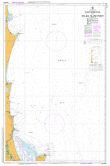
AUS 815
Cape Moreton To Double Island Point
Please note that all charts are nominally folded in half for storage and handling as per the marine industries standard.
If you require an unfolded copy (ie: flat for framing), please select Flat Paper, and we will organise a special print service to accomodate your request.
Description
This official Nautical Chart is produced by the Australian Hydrographic Office, and corrected fortnightly to 'Notice to Marines' by Cairns Charts & Maps. This ensures it remains compliance with Safety of Navigation requirements. This marine chart, or 'sea map', is primarily produced to support the safe navigation of commercial shipping through Australian, Papua New Guinea and Solomon Island waters.
Nautical charts depict the seabed, or bathymetry, using a variety of colours to shade the depth regions. Darker blues indicate shallower water, while light blues and white indicate deeper water. A chart will also show continuous contour lines (at varying intervals depending on the scale of the chart), 'spot depths' across the whole area, as well as different symbols indicating wrecks, shallow rocks and dangers, as well as details on lights, light houses, tides and currents.
For extensive detail on the symbology of nautical charts, the Symbols and Abbreviations used on Admiralty Charts is the definitive reference.
Barwon Bank Caloundra Coolum Beach Donnybrook Kawana Waters Marcoola Maroochydore Mooloolaba Mudjimba Ningi Noosa Heads Peregian Beach Rainbow Beach Toorbul Woorim Yaroomba Teewah Alexandra Headland Alexandra Headland Beach Alexandria Bay Alexandria Beach Arkwright Shoal Point Arkwright Battery Hill Bells Creek Bells Creek North Branch Bells Creek South Branch Blowhole Or Roaring Cave Bray Rock Braydon Beach Brennan Shoal Bribie Island Broutha Waterhole Buderim Mountain Bulcock Beach Bullock Creek Bulwer Bunbubah Creek Burgess Creek Caloundra Head Carlo Point Cartwright Castaways Creek Chambers Island Channel Island Cape Cliff Comboyuro Point Coochin Creek Cooloola Cooloola Sand Patch Lake Cooloomera Coolum Creek Mount Coolum Coondibah Creek Coondibah Lagoon Coonowrin Creek Cornmeal Creek Currimundi Creek Deep Water Point Devils Kitchen Dicky Beach Dingo Creek Dolphin Point Doonan Creek Double Island Point Dux Creek East Bank Eenie Creek Egg Island Eight Mile Rocks Elimbah Creek Emu Swamp Eurungunder Hill Fairy Pools Five Hills Flinders Reef Freshwater Creek Freshwater Lake Gallagher Point Glass Mountain Creek Gneering Shoals Goat Island Golden Beach Granite Bay Halls Bay Halls Creek Hamilton Patches Hancock Shoal Hay Island Heath Island Hells Gates Hixson Banks Hook Point Hussey Creek Hutchison Shoal Inner Freeman Channel Inskip Point Irwin Creek Jabiru Swamp Jew Shoal Keyser Channel Keyser Creek Keyser Island Kianga Channel Kings Beach Laguna Bay Lamerough Creek Lion Rock Little Freshwater Creek Little Goat Island Long Island Marcoola Beach Marcus Beach Marcus Creek Maroochy River Maroochydore Beach Meridan Plains Mermaid Lagoon Middle Bank Mission Point Moffat Beach Moffat Head Mooloolaba Beach Mooloolaba Harbour Mooloolah River Cape Moreton Mountain Creek Mudjimba Beach Mudjimba Island Munna Point Murdering Creek Ningi Creek Ningi Island Noosa Head Noosa Hill Noosa Inlet Noosa River Noosaville North Channel North East Channel North Head North Heads North Point North Spit North West Channel Outer Freeman Channel Oyster Rocks Paradise Caves Peregian Creek Mount Peregian Point Perry Picnic Point Pincushion Island Poona Lake Poverty Creek Pumicestone Channel Pumicestone Creek Raper Shoal Roaring Cave Roberts Shoal Rocky Hill Ross Island Salamander Bank Saltwater Creek Searys Creek Seawah Hill Semaphore Creek Shelly Beach Sippy Creek Skirmish Banks Skirmish Passage Smith Smith Peak Smith Rock South Channel South Spit Spitfire Banks Spitfire Beach Stumer Creek Sunshine Beach Sunshine Creek Sylvan Beach Tabilbulla Tallallebela Teewah Beach Teewah Coloured Sands Thannae Waterhole The Bar The Stairway Thooloora Island Toboggan Hill Tooloora Creek Toorbul Point Tooway Creek Tuckers Creek Tungewa Turners Camp Island Venus Banks Welsby Lagoon Weyba Creek Lake Weyba Whites Lookout Wide Bay Wild Banks Wisemans Lookout Witches Cauldron Wolf Rock Woolaan Yaroomba Beach Yellow Patch Yule Road The Skids North Banks Cotton Tree Castaways Beach Bribie Island National Park Currimundi Lake Conservation Park Keyser Island Conservation Park Maroochy River Conservation Park Mount Coolum National Park Weyba Creek Conservation Park Cooloola Beach Sunrise Beach Mooloolah River National Park Bullock Creek Conservation Park Double Island Point Conservation Park Cape Moreton Conservation Park Inskip Tea Tree Bay Noosa Resources Reserve Ex-Hmas Brisbane Conservation Park Peregian Springs Noosa National Park Aroona Birtinya Bokarina Bribie Island North Buddina Caloundra West Currimundi Little Mountain Minyama Palmview Parrearra Pelican Waters Shelly Beach Caloundra City Warana Wurtulla Sippy Downs Buderim Pacific Paradise Twin Waters Meldale Banksia Beach Bellara Bongaree Sandstone Point Welsby White Patch Wide Bay Harbour South Bank Cherry Venture Noosa Alexandra Bay Lake Weuba Emu Mountain Mount Perigian Coolum Coolum Hill Mudgimba Island Old Woman Island Gneering Shoal Alexandra Head Alexandra-Mooloolaba Raper Point Ferguson Spit Dickey Beach Wickham Point Bell Creek Howe Channel Glass House Mountain Creek Wilds Bank Wilds Banks Outer Freeman Channnel Bribie View Gallagher Point Spitfire Bank Pumice Stone Strait Freeman Channel Parrot Island Ridge Tree Hill Old Bribie Spitfire Channel Ducks Creek Shields Point Skirmish Pass Bulwer Cottages Comboyro Point Yule Roads Skirmish Point Pearl Channel Maclaglan Ridge Bulwer Valley Diagram Hills Diagram Hill Blue Lagoon