
AUS 81
Approaches To Geraldton
Please note that all charts are nominally folded in half for storage and handling as per the marine industries standard.
If you require an unfolded copy (ie: flat for framing), please select Flat Paper, and we will organise a special print service to accomodate your request.
Description
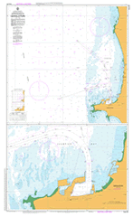
This official Nautical Chart is produced by the Australian Hydrographic Office, and corrected fortnightly to 'Notice to Marines' by Cairns Charts & Maps. This ensures it remains compliance with Safety of Navigation requirements. This marine chart, or 'sea map', is primarily produced to support the safe navigation of commercial shipping through Australian, Papua New Guinea and Solomon Island waters.
Nautical charts depict the seabed, or bathymetry, using a variety of colours to shade the depth regions. Darker blues indicate shallower water, while light blues and white indicate deeper water. A chart will also show continuous contour lines (at varying intervals depending on the scale of the chart), 'spot depths' across the whole area, as well as different symbols indicating wrecks, shallow rocks and dangers, as well as details on lights, light houses, tides and currents.
For extensive detail on the symbology of nautical charts, the Symbols and Abbreviations used on Admiralty Charts is the definitive reference.
Drummond Cove Geraldton 4 Fathom Bank Allendale Primary School Back Beach Batavia Coast Boat Harbour Beachlands Beachlands Primary School Beresford Bluff Point Bluff Point Camp School Bluff Point Primary School Champion Bay Champion Bay Beach Chapman River Crowtherton Fishing Boat Harbour Geraldton Baptist Church Geraldton Grammar School Geraldton Harbour Geraldton Health Campus Geraldton Primary School Geraldton Senior College Glenfield Glenfield Beach Greys Beach Holland Street School Lillian Shaw Park Mahomets Flats Meekawaya Aboriginal Pre-School Mount Scott Pages Beach Pioneer Memorial Park Point Moore Point Moore Reefs Port Grey Separation Point St Francis Xavier Primary School St Lawrences School Sunset Beach Town Beach Waggrakine Siding Webberton West End Wokarina Siding Wokarena Wokarena Siding Popes Landing Drummonds Cove Smugglers Cove Glenfield Station Sandy Hill Waggrakine Chapman Station Bluff Point Junction Inner Knoll Outer Knoll Four Fathom Bank Scott Hill Point Separation