
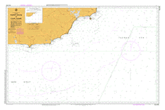
AUS 805
Point Hicks To Cape Howe
Please note that all charts are nominally folded in half for storage and handling as per the marine industries standard.
If you require an unfolded copy (ie: flat for framing), please select Flat Paper, and we will organise a special print service to accomodate your request.
Description
This official Nautical Chart is produced by the Australian Hydrographic Office, and corrected fortnightly to 'Notice to Marines' by Cairns Charts & Maps. This ensures it remains compliance with Safety of Navigation requirements. This marine chart, or 'sea map', is primarily produced to support the safe navigation of commercial shipping through Australian, Papua New Guinea and Solomon Island waters.
Nautical charts depict the seabed, or bathymetry, using a variety of colours to shade the depth regions. Darker blues indicate shallower water, while light blues and white indicate deeper water.A chart will also show continuous contour lines (at varying intervals depending on the scale of the chart), 'spot depths' across the whole area, as well as different symbols indicating wrecks, shallow rocks and dangers, as well as details on lights, light houses, tides and currents.
For extensive detail on the symbology of nautical charts, the Symbols and Abbreviations used on Admiralty Charts is the definitive reference.
Fairhaven Lake View Korbethong Cann River Mallacoota Gipsy Point Allan Black-Allan Line Cape Howe Conference Point Palmer Wauka Worange Bunyip Hole Alfred National Park Allans Creek Allans Head Baawang Baker Bight Band Stand Bank Stand Barga Camp Creek Bastion Rocks Point Beehive Creek Benedore River Bennetts Knob Betka Betka Beach Betka River Betka Swamp Big Bog Black Creek Bloomer Creek Bluenose Creek Granite Creek Bralak Branch Creek Brindat Brown Point Browns Creek Bucklands Jetty Campshot Point Cann River West Branch Cann River Cemetery Cann River Fire Station Cann River P-12 College Cann River Police Station Cann River Post Office Cann River Primary School Cann River Public Hall Cann Valley State Forest Cape Horn Cape Horn Bay Cape Horn Creek Cape Howe Wilderness Zone Captains Creek Captains Point Cemetery Bight Centre Shot Charlies Creek Clinton Rocks Clinton Rocks Creek Cloke Rock Coolwater Creek Coulls Point Crawfords Creek Croajingolong National Park Dahl Bank Davis Creek Dead Finish Develings Gulch Develings Inlet Devilings Inlet Dingo Creek Dinner Creek Dorran Bight Double Creek Double Creek Arm Drummer Creek Drummer State Forest Little River Eight Foot Bank Elusive Lake Fisheries Point Flynns Creek Franks Tank Gabo Gabo Harbour Gabo Island Gales Hill Genda Creek Genoa Genoa Falls Genoa Peak Genoa Primary School Genoa Public Hall Genoa River Jetty Georges Creek Gibbs Creek Goanna Bay Goat Island Goodwin Sands Governors Bend Granite Peak Gravelly Point Halls Creek Seek Creek Harrison Hole Harrisons Channel Harrisons Hole Horse Island Howe Bight Howe Creek Howe Flat Howe Hill Howe Range Iron Prince Isman Inlet Jims Creek White Gum Creek Jimms Creek Jimmy Point John Bull Light Jungle Creek Kangaroo Point Kanuka Creek Karbeethong Jetty Karlo Karlo Creek Kingfish Creek Kingfisher Point Kooragan Lake Barracuta Lake Furnell Lake Wau Wauka Lawson Point Leeser Bight Leeser Bluff Link Camp Creek Mount Little Drummer Little Ram Head Little Rame Head Lomond Hill Long Reef Lyrebird Point Mallacoota Airstrip Mallacoota Fire Station Mallacoota Inlet Mallacoota Inlet Bottom Lake Mallacoota Inlet Top Lake Mallacoota P-12 College Mallacoota Police Station Mallacoota Primary School Scrubby Creek Mangan Lake Maxwell Point Maxwells Mine McKenzie Bight McMillan Mine Monaro Highway Mount Buckle Mosquito Creek Mount Cavell Mount Drummer Mount Everard Mount King Mount Reed Muddy Inlet Mueller River Mullet Creek New Zealand Star Bank Noorinbee Noorinbee Fire Tower Noorinbee Primary School O'Mearas Creek O'Mearas Lagoon Palmer Bank Peach Tree Creek Peachtree Creek Camping Ground Pelican Point Petrel Point Pipe Clay Creek Pipeclay Creek Pipeclay Point Point Hicks Point Hicks Lighthouse Point To Point Bight Quambie Point Quarry Beach Rabbit Island Rame Head Red River Reed Bed Creek Reedy Creek Reedy-Thurra Divide Refuge Cove Robertson Bight Robertsons Bight Rocky Creek Sandy Patch Point Sandpatch Point Sandy Point Sandy Point Picnic Ground Scudder Creek Seal Cove Seal Creek Secret Beach Serpentine Creek Shady Gully Shady Creek Bushland Reserve Sheep Station Creek Shipwreck Creek Shipwreck Creek Camping Area Smellie Creek Smellys Creek Smellys Inlet Snapper Point Soda Creek Sou' West Arm South West Arm Spotted Dog Creek Spotted Dog Mine Steves Creek Stingray Point Stony Peak Surprise Creek Swimming Point Sword Creek Sword Grass Creek Tamboon Tamboon Hill Tamboon Inlet Tasman Sea Tea Tree Creek Tea Tree Point Telegraph Point The Big Bight The Narrows The Skerries Thurra Thurra River Thurra Swamp Tobins Creek Tonghi Tonghi Creek Toonyarak Top Shot Totem Point Treacys Lookout Tullaburga Island Two Mile Creek Wau Wauka Wau Wauka West Whaleback Rock Wingan Wingan Inlet Wingan Inlet National Park Wingan Point Wingan Research Plot Wingan River Wingan Swamp Wombat Hill Wooyoot Yoke Up Creek Genoa River Wau Wauka Lake Cunawurrae Barracoota Lake Mallacoota Lake Mallagoota Inlet Karbeethong Tullaberga Island Tullaburnga Island Bastion Point Everard Hill Sand Patch Point Tamboon River Tamboon South Toolaway River Ram Head Cape Everard