
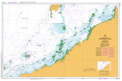
AUS 743
Barrow Island To Onslow
Please note that all charts are nominally folded in half for storage and handling as per the marine industries standard.
If you require an unfolded copy (ie: flat for framing), please select Flat Paper, and we will organise a special print service to accomodate your request.
Description
This official Nautical Chart is produced by the Australian Hydrographic Office, and corrected fortnightly to 'Notice to Marines' by Cairns Charts & Maps. This ensures it remains compliance with Safety of Navigation requirements. This marine chart, or 'sea map', is primarily produced to support the safe navigation of commercial shipping through Australian, Papua New Guinea and Solomon Island waters.
Nautical charts depict the seabed, or bathymetry, using a variety of colours to shade the depth regions. Darker blues indicate shallower water, while light blues and white indicate deeper water. A chart will also show continuous contour lines (at varying intervals depending on the scale of the chart), 'spot depths' across the whole area, as well as different symbols indicating wrecks, shallow rocks and dangers, as well as details on lights, light houses, tides and currents.
For extensive detail on the symbology of nautical charts, the Symbols and Abbreviations used on Admiralty Charts is the definitive reference.
Onslow 16 Mile Well 1a New Bore 2 Mile Well 3 Mile Well 4 Mile Creek 5 Mile Creek 5 Mile Well 6 Mile Well 7 Mile Well 8 Mile Bore 9 Mile Well Airlie Island Andy Well Angle Island Ashburton Island Ashburton Road Ashley Well Ashworth Shoal Australind Shoal Balkadadja Bore Balkadadja Claypan Ballabonny Well Balmoral Bandicoot Bay Baresand Point Barrigoombar Claypan Barrigoombar Well Barrow Island Barrow Island Aerodrom Barrow Island Nature Reserve Barrow Island Shoals Beadon Bay Beadon Creek Beadon Point Bessieres Island Bilanoo Hill Bilanoo Pool Birthday Hill Black Ledge Bob Bore Boodie Island Boundary Well Bowers Ledge Bradley Well Brewis Reef Bulaloo Well No. 47 Bullinnarwa Pool Campbell Well Cane River Cape Carnie Cape Don Shoal Cape Poivre Cape Preston Carattis Carey Island Carrawar Pool Carrawar Well Carraweela Well Casuarina Point Centenary Well Chinginarra Well Cheudawa Well Chuerdoo Pool Cliff Spring Congo Bore Coolangara Hill Coolangara Well Coolgra Point Coonga Creek Coonga Well Cooper Well Corner Shoals Corner Well Corridor Bore Cowle Island Cowpaddock Well Coxes Well Crossroads Bore Cullatha Well Cundill Bore Curlew Bank Curramuna Waterhole Currangi Well Dam Bore Daniels Bore Davie Well Deep Well Deepdale Delaney Hill Dinner Camp Bore Diorite Well Direction Island Diver Inlet Du Boulay Creek Du Boulay Well Dukes Well Eagles Nest East Island Echo Bluff Edward Creek Eliassen Rocks Entrance Point Ernie Bore Eve Well Fairway Shoals False Island Flinders Shoal Flyn Well Fortescue Bridge Fortescue Island Fortescue Reef Fortescue River Fortescue River Roadhouse Fortescue Road Fortescue Rock Fortescue Well Frankland Well Garden Well Gem Bore George Well Gerald Creek Glennie Patches Gorgon Patch Gravel Banks Great Sandy Island Great Sandy Island Nature Reserve Hastings Shoal Hayman Rock Herald Reef Hilda Well Hooley Creek Horn Well Hubert Well Inner North West Patch Jack Bore James Point Jennys Bore Jilanjilan Pool Jilanjilan Well Jimbegnyinoo Pool Jubilee Well Junction Well Jungle Bore King Well Kinley Well Koolinda Patch Koolumba Pool Landing Well Large Island Lawn Well Lea Well Lightfoot Reef Little Hill Little Rocky Island Little Rocky Island Nature Reserve Little Shoals Locker Island Locker Island Nature Reserve Locker Reef Long Island Macks Bore Mangrove Islands Mangrove Passage Manicom Bank Marda Pool Marda Well Mardawinjare Waterhole Mardie Mardie Bore Mardie Creek Mardie Island Mardie Pool Mardie Rock Mardie Station Airfield Mary Anne Group Mary Anne Island Mary Anne Passage Mary Anne Passage Light Mary Anne Reef Meda Reef Meg Well Melayarra Waterhole Melon Well Metters Bore Middle Bore Middle Island Middle Mangrove Island Middle Mary Anne Island Middle Passage Island Miles Shoal Monkey Well Moresby Shoals Mount Nicholson Mount Potter Mount Preston Mount Rough Mount Salt Mulga Dam Bore Multhuwarra Pool Mulyering Well Mungajee Pool Mungarathoona Creek Murnda Bore Murray Well Myanore Creek Nares Rock Neera Well No. 46 Well Noonamoony Well North East Twin Island North Island North Sandy Island Nuilee Nowra Creek Nunyinggo Pool O'Grady Shoal Onslow Aerodrome Onslow District Hospital Onslow Primary School Outer North West Patch Parkes Reef Paroo Shoal Pasco Island Passage Island Passage Islands Peace Well Peach Tree Bore Peedamulla Peedamulla Creek Peedan Hill Peewar Well Penguin Bank Peter Creek Peter Well Petersen Rock Pilling Well Pinagee Well Pindalla Creek Pindooral Camp Pindooral Clayhole Pindral Outcamp Poivre Reef Port Weld Potter Island Preston Island Preston Spit Princess Well Pup Island Queen Well Richardson Shoal Ripple Shoals Robe Bridge Robe Hill Robe Point Robe River Robe Soaks Rockhole Bore Roller Shoal Rosily Islands Rosily Shoals Round Island Saddle Hill Saddleback Hill Saladin Shoal Salt Well Sambo Pass Santo Rock Secret Well Serrurier Island Serrurier Island Nature Reserve Shark Point Shepherds Well Sheryl Bore Sholl Creek Sholl Island Solitary Island South End South Island South Passage Island South West Patch South West Twin Island Steamboat Island Stewart Island Stewart Pool Stewart Rocks Stokes Point Sugarloaf Hill Sultan Reef Sunrise Beach Sunset Beach Surprise Well Table Island Tanga Tanga Creek Tarda Pool Tarquin Well Taunton Reef Telegraph Bore Terminal Creek Terry Bore Thalanyji Oval The Chair The Ledge The Man In the Boat Thevenard Island Thevenard Island Nature Reserve Three Peak Hill Thringa Island Tin Hut Well Tod Bore Tom Bull Pool Tongue Shoal Toondy Well Tortoise Island Tragedy Bore Trap Reef Trevarton Creek Twin Islands Violet Well Wallanaring Creek Wallaroo Waterhole Walleroo Well Wapet Camp Ward Reef Warralee Well Warralooree Claypan Warramboo Warramboo Creek Warramboo Well Wealumba Well Weeks Shoal Weerawandie Well Weld Island West Island West Reef White Gate Well Windoo Soak Windoo Well Woolawandawoolana Well Woolhouse Well Woolie Paddock Well Woorawa Camp Wooroo Creek Wooroo Pool Yabberoo Well Yagobiddy Creek Yammadery Creek Yammadery Island Yandaja Clayhole Yank Well Yardi River Yardie Landing Yarraloola Yarraloola Mine Yarraloola Station Airfield Yathalla Community Yimburn Hill The Man in the Boat Steamboat Islet Preston Islet OGrady Shoal Eramurra Creek Stewart Islet Stakes Point Fortescue Islet Fortescue Rocks North Fortescue Reef Mangrove Island Mardi Island Mardi Islet South Fortescue Reef Pasco Islet Eliasson Rocks Round Islet Mardi Rock Long Islet Middle Islet Fortescue Coonga Bore Solitary Islet North Sandy Islet Passage Islet Barrow Island Shoal South Passage Islet Jilanonlan Pool Balmoral Out Camp Two Mile Well Pup Islet Beagle Island Mardie West Moolyaning Well East Islet Cowayou Peters Creek Low Island Low Islet Middle Mary Ann Island Large Islet Mary Anne Islands Mary Ann Group West Islet Bulaloo Well Melayarra Well False Islet Cheedawa Well Nunyingoo Pool Weld Islet Saladin Marine Terminal Pindooral Waterhole Little Rocky Islet Naples Rock Mardawinjare Well North-east Twin Islet South-west Twin Islet Anchor Island Direction Islet Mary Ann Point Mary Anne Point Tortoise Islet Ashburton Islet Wallaroc Wells Wanga Noo Table Islet Outer Northwest Patch Inner Northwest Patch Tongue Shoals Sugarloaf Peedamullah Creek Mookridi Well Ashburton River Curlew River Old Onslow Locker Islet Yandaja Waterhole