
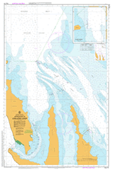
AUS 74
Approaches To Useless Loop
Please note that all charts are nominally folded in half for storage and handling as per the marine industries standard.
If you require an unfolded copy (ie: flat for framing), please select Flat Paper, and we will organise a special print service to accomodate your request.
Description
This official Nautical Chart is produced by the Australian Hydrographic Office, and corrected fortnightly to 'Notice to Marines' by Cairns Charts & Maps. This ensures it remains compliance with Safety of Navigation requirements. This marine chart, or 'sea map', is primarily produced to support the safe navigation of commercial shipping through Australian, Papua New Guinea and Solomon Island waters.
Nautical charts depict the seabed, or bathymetry, using a variety of colours to shade the depth regions. Darker blues indicate shallower water, while light blues and white indicate deeper water. A chart will also show continuous contour lines (at varying intervals depending on the scale of the chart), 'spot depths' across the whole area, as well as different symbols indicating wrecks, shallow rocks and dangers, as well as details on lights, light houses, tides and currents.
For extensive detail on the symbology of nautical charts, the Symbols and Abbreviations used on Admiralty Charts is the definitive reference.
Useless Loop Ant Island Bar Flats Bellefin Flats Bellefin Prong Big Lagoon Black Rocks Blind Strait Broken Down Head Cape Bellefin Cape Heirisson Cape Ransonnet Colaert Bay Denham Channel Denham Sound Dirk Hartog East Sand Egg Island Egg Island Nature Reserve Fitzys Mill Freycinet Reach Friday Island Gabber Point Garden Well Gerritsen Cove Heirisson Flats Heirisson Prong Inner Bar Kells Rock Longtom Bay Meade Island Middle Bluff Monkey Rock North Sand Notch Point Outer Bar Passage Well Quoin Bluff South Ransonnet Rocks Sandy Point Shelter Bay Shoal Flats Slope Island Smith Rocks South Passage South Sand Steep Point Sunday Bay Sunday Island Sunday Island Nature Reserve Surf Point Tumbledown Point Two Wells Useless Inlet Useless Loop Primary School Wilya Mia Yabbra Well The Quoin Bluff The Quoin Bluff South Tetrodon Island Point Refuge Middle Flat Shark Bay Salt Works