
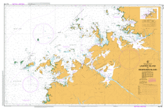
AUS 730
Lamarck Island To Degerando Island
Please note that all charts are nominally folded in half for storage and handling as per the marine industries standard.
If you require an unfolded copy (ie: flat for framing), please select Flat Paper, and we will organise a special print service to accomodate your request.
Description
This official Nautical Chart is produced by the Australian Hydrographic Office, and corrected fortnightly to 'Notice to Marines' by Cairns Charts & Maps. This ensures it remains compliance with Safety of Navigation requirements. This marine chart, or 'sea map', is primarily produced to support the safe navigation of commercial shipping through Australian, Papua New Guinea and Solomon Island waters.
Nautical charts depict the seabed, or bathymetry, using a variety of colours to shade the depth regions. Darker blues indicate shallower water, while light blues and white indicate deeper water. A chart will also show continuous contour lines (at varying intervals depending on the scale of the chart), 'spot depths' across the whole area, as well as different symbols indicating wrecks, shallow rocks and dangers, as well as details on lights, light houses, tides and currents.
For extensive detail on the symbology of nautical charts, the Symbols and Abbreviations used on Admiralty Charts is the definitive reference.
Adenotricha Creek Adieu Point Agu Ngalangalangali Andandilia Anderdon Islands Argunalang Nalang Ngari Arlu Mai Yordu Association Inlet Atrina Island Atys Island Augereau Island Augustus Island Augustus Water Bat Island Battery Point Bernouilli Island Black Rocks Bluff Hill Bonaparte Island Booby Island Boongaree Island Brecknock Harbour Brown Inlet Browne Island Brunswick Bay Buckland Point Buffon Island Bumpus Island Bundolgwa Creek Byam Martin Island Calliance Point Camden Harbour Camden Peninsula Camden Sound Cape Brewster Cape Torrens Cape Wellington Careening Bay Careening Island Cascade Creek Champagny Island Champagny Islands Chanake Coffee Royal Colbert Island Commerson Island Conical Hill Coronation Island Coronation Islands Cotton Island Cymo Island D'Aguesseau Island D'Arcole Islands Darcy Island De Freycinet Islet Deception Bay Degerando Island Desaix Islands Desfontaines Island Didja Djarumu Island Donkins Hill Duguesclin Island Dunedale Creek Ena Island Enid Falls Entrance Island Etisus Island Fern Gully Fish River Fontanes Island Forbin Island Gale Island Gandalwolgari Hill Gap Island Gariyeli Creek Glauert Island Granite Island Green Island Greville Island Grey Island Halfway Bay Hall Point Hampton Downs Hanover Bay Hardy Point Hedley Island Heywood Island Heywood Islands High Bluff Hope Point Hull Bank Hummock Island Hunter River Imorogu Tabletop Iradi Hill Iredale Island Ivy Cove Jackson Island Jolialgum Creek Jungulu Island Kannamatju Island Kartja Island Keraudren Island Kid Island King Cascade Kumpanapirra Creek Kunmunya Kunmunya Hill Kuri Bay Kuringna Lamarck Island Lammas Island Laseron Island Latirus Island Lorikeet Shoal Low Rock Lucas Island Lulim Island Lushington Valley Mably Island Macdonald Range Manning Peak Mariawala Falls Marigui Promontory Marun Mcculloch Island Mcrae River Miawaja Island Mictyis Island Midway Island Mitchell Plateau Momorinyam Creek Moran River Mosquito Flats Mount Anderdon Mount Batten Mount Brookes Mount Double Cone Mount Eyre Mount King Mount Knight Mount Lookover Mount Lyell Mount Sturt Mount Trafalgar Mount Trevor Mount Waterloo Mount York Mulamulonya Crossing Munster Water Murrara Island Museums Island Naturalists Beach Naturalists Island Needle Rock Ninintjitji Norgor Inlet North Entrance Numanbu Island Numardin Hill Nyimandum Okenia Island One Tree Island Orange Shoal Osborn Reefs Parin Peninsula Perseverance Inlet Point Augustus Port George Iv Port Nelson Prince Frederick Harbour Prince Regent Nature Reserve Prince Regent River Princess May Ranges Purulba Pyrene Island Python Cliffs Quinlan Channel Rainbow Shoals Rathbun Island Red Island Rice Rocks Rocky Islands Roe River Rogers Strait Rothsay Water Rufous Creek Sampson Inlet Serene Island Sheep Island Sholl Point Sight Point Slade Island Slate Islands South Entrance South Wailgwin Island Spitfire Creek Square Hill St Andrew Island St George Basin St Patrick Island Strong Tide Point Tanpanmirri Island Thais Island Tjanganagu Kangadin Tjungkurakutangari Island Tournefort Island Treachery Head Umbanganan Island Uwins Island Violet Shoal Vulcan Island Vulcan Islands Wailgwin Island Walker Valley Waring Island Whateley Range Whirlpool Point Whitley Island Wickham Island Wildcat Reefs Wilson Point Winmiri Wodawoda Woodward Island Wurrulgu Inlet York Sound Cape Pond Colbert Islet Fontanes Islet Desaix Island Desaix Islet DArcole Islands Buffon Islet Malby Island Malby Islet Anderdon Islets Kenandren Islet Mobly Island De Freycinet Island Freycinet Island Bernouill Islet White Island White Islet Forbin Islet Bat Islet Duguesclin Islet Rocky Islets Browne Islet Commerson Islet Commersun Islet DAguesseau Island DAguesseau Islet Jackson Islet Lucas Islet Red Islet Adiew Point Vulcan Islets Munster Waters Greville Islet Hummock Islet Degerando Islet Saint Andrew Island Saint Patrick Island Saint Patrick Islet Port George IV Port George the Fourth Kwinana Mission Kunmainya Mission Station Kunmunya Mission Kwinana Saint George Basin Brecknock Island Breaknock Island New Island New Islet Breaknock Harbour Bumpus Islet Slate Islets Marie Springs Mount Stewart Whately Range Kid Islet Claret Island Thorne Reef Thorne Reefs Thorn Reef