
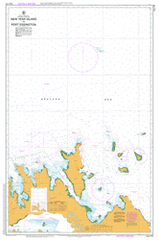
AUS 714
New Year Island To Port Essington
Please note that all charts are nominally folded in half for storage and handling as per the marine industries standard.
If you require an unfolded copy (ie: flat for framing), please select Flat Paper, and we will organise a special print service to accomodate your request.
Description
This official Nautical Chart is produced by the Australian Hydrographic Office, and corrected fortnightly to 'Notice to Marines' by Cairns Charts & Maps. This ensures it remains compliance with Safety of Navigation requirements. This marine chart, or 'sea map', is primarily produced to support the safe navigation of commercial shipping through Australian, Papua New Guinea and Solomon Island waters.
Nautical charts depict the seabed, or bathymetry, using a variety of colours to shade the depth regions. Darker blues indicate shallower water, while light blues and white indicate deeper water. A chart will also show continuous contour lines (at varying intervals depending on the scale of the chart), 'spot depths' across the whole area, as well as different symbols indicating wrecks, shallow rocks and dangers, as well as details on lights, light houses, tides and currents.
For extensive detail on the symbology of nautical charts, the Symbols and Abbreviations used on Admiralty Charts is the definitive reference.
Minjilang Adam Head Adjamarragu Adjamarragu Airstrip Adjamarrugu Point Ajamuji Creek Alamirra Annesley Point Arrgamurrmur Barrow Bay Bay Hill Bedford Head Berkeley Bay Black Point Bluff Point Bowen Strait Bramble Rocks Britomart Shoal Brogden Point Buffalo River Buni-Inwunbuluk Cabbage Ground Caiman Creek Campbell Reef Cape Cockburn Cape Croker Cobourg Cobourg Marine Park Cockle Island Coombe Point Copeland Island Cowlard Island Croker Island Croker Island Barge Landing Curlew Bay Curlew Point D' Urville Point Danger Point Darch Island Darmarl Point De Courcy Head Djmngan Point East Bay East Station Point Edwards Point False Turtle Point Falstaff Island Fern Creek First Island Fort Wellington Garig Gunak Barlu National Park Giles Point Gningarg Point Grant Island Guialung Point Gul Gul Gumeragi Hickeys Creek High Point Ilamaryi River Inngirnatj Irgul Point Jones Shoal Kangaroo Point Kennedy Bay Knocker Bay Kuper Point Lawson Island Lizard Bay Malay Bay Mamaruni School Mangrove Point Mariah Marramarrani Mawuwu Creek Mc Cluer Island Meander River Middle Head Minjilang Health Centre Minjilang Police Station Minto Head Mission Bay Morse Island Mountnorris Bay Murgenella Ranger Station Murgenella Wildlife Sanctuary Murri Point Musquito Creek New Year Island North Creek Observation Cliff One Tree Point Oxley Island Oyster Point Palm Bay Peacock Island Point David Point Escape Point Sleeman Port Bremer Port Essington Priest Point Raffles Bay Record Point Reef Point Saddle Hill Sandy Bay Sandy Island No 2 Sandy Island Number 1 Second Island Sir George Hope Islands Sleemans Creek Smith Point Somerville Bay Spear Point Spiral Bay Stewart Point Table Head Templer Island Tigers Camp Timor Springs Turtle Island Turtle Point Valencia Island Victoria Settlement Wa Wu-I Billabong Walka Walunga Swamp Wanakutja Wangaran Swamp Wangarlu Bay Wangewanja Cove Wangoindjung Island Warigili Point Warla Island Warldagawaji Island Wauk Wauk Aerodrome Wauk Lagoon West Bay West Station Point White Cliff Wilgi Wirgungun Point Woods Island Wunmiyi Island Wurgurlu Bay Money Shoal Bramble New Year Islet Orontes Reef Lawson Islet McCluer Island McClure Island Sandy Island Number 2 Grant Islet Darch Islet Durville Point Templer Islet Cowlard Islet Earl River DeCourcy Head Cobourg Peninsula Coburg Peninsula Wangewanga Cove Wanjewanja Cove Valentia Island Murgenella Settlement May Day Island Billabong Wa Wu-i