
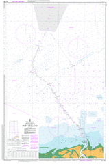
AUS 53
Approaches To Port Hedland
Please note that all charts are nominally folded in half for storage and handling as per the marine industries standard.
If you require an unfolded copy (ie: flat for framing), please select Flat Paper, and we will organise a special print service to accomodate your request.
Description
This official Nautical Chart is produced by the Australian Hydrographic Office, and corrected fortnightly to 'Notice to Marines' by Cairns Charts & Maps. This ensures it remains compliance with Safety of Navigation requirements. This marine chart, or 'sea map', is primarily produced to support the safe navigation of commercial shipping through Australian, Papua New Guinea and Solomon Island waters.
Nautical charts depict the seabed, or bathymetry, using a variety of colours to shade the depth regions. Darker blues indicate shallower water, while light blues and white indicate deeper water. A chart will also show continuous contour lines (at varying intervals depending on the scale of the chart), 'spot depths' across the whole area, as well as different symbols indicating wrecks, shallow rocks and dangers, as well as details on lights, light houses, tides and currents.
For extensive detail on the symbology of nautical charts, the Symbols and Abbreviations used on Admiralty Charts is the definitive reference.
Port Hedland 4 Mile Creek Airey Point Anderson Point Bhp Billiton Marrapikurinya Park Burgess Point Captain Bert Madigan Park Colin Matheson Oval Cooke Point Cooke Point Primary School Cornelisse Shoal Coxon Shoal Don Rhodes Mining Museum Park Downes Island East Creek Finucane Finucane Island Hansen Hill Harbour Hill Harriet Point Hunt Hill Hunt Point Indian Ocean Laurentius Point Mainstreet Jetty Mangrove Point Minilya Sandbank Nelson Point North Point Owen Point Oyster Point Port Hedland Community Park Port Hedland Primary School Port Hedland Regional Hospital Port Hedland School of the Air Pretty Pool Pretty Pool Creek Salmon Creek Shell Hill Spinifex Hill Spoil Bank St Cecilias College Stanley Point Stingray Creek Weerdee Island West Creek West Hill Minilya Bank Oyster Inlet South West Creek Goldsworthy Pier Flat Rock Mount Newman Wharf Cemetery Hill