
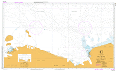
AUS 454
Wilkes Land
Please note that all charts are nominally folded in half for storage and handling as per the marine industries standard.
If you require an unfolded copy (ie: flat for framing), please select Flat Paper, and we will organise a special print service to accomodate your request.
Description
This official Nautical Chart is produced by the Australian Hydrographic Office, and corrected fortnightly to 'Notice to Marines' by Cairns Charts & Maps. This ensures it remains compliance with Safety of Navigation requirements. This marine chart, or 'sea map', is primarily produced to support the safe navigation of commercial shipping through Australian, Papua New Guinea and Solomon Island waters.
Nautical charts depict the seabed, or bathymetry, using a variety of colours to shade the depth regions. Darker blues indicate shallower water, while light blues and white indicate deeper water. A chart will also show continuous contour lines (at varying intervals depending on the scale of the chart), 'spot depths' across the whole area, as well as different symbols indicating wrecks, shallow rocks and dangers, as well as details on lights, light houses, tides and currents.
For extensive detail on the symbology of nautical charts, the Symbols and Abbreviations used on Admiralty Charts is the definitive reference.
Petersen Jenluise Blunt Bay Ivanoff Head Hatch Islands Adams Glacier Mallory Point Brooks Point Law Dome Law Dome Summit Wilkins Runway Davis Islands Hudson Island Cape Nutt Underwood Glacier Vanderford Glacier Haupt Nunataks Snyder Rocks Hawkins Glacier Reist Rocks Knox Coast Robinson Glacier Vincennes Bay Alexander Nunataks Budd Coast Eyres Bay Campbell Nunatak Birkenhauer Island Merritt Island Peterson Island Browning Peninsula Boffa Island Longs Nunatak Snedeker Glacier Wilson Island Bosner Island Teigan Island Motherway Island Niles Island Knowles Passage Penney Bay Williams Nunatak Sack Island Werlein Island Zimmerman Island Grace Rocks Holl Island O'Connor Island Cloyd Island Peterson Glacier Goldenberg Ridge Churchill Point Ford Island Herring Island Du Beau Glacier Hiegel Passage Orton Cave Cave Landing Cave Ravine Ardery Island Penney Landing Odbert Island Robertson Landing Mast Point Penney Ravine Soucek Ravine Robinson Ridge Kros Moraine Windmill Islands Sparkes Bay Apfel Glacier Lake Ptichje Lake Dalekoje Midgley Reefs Ommundsen Island Warrington Island Hollin Island Midgley Island Pidgeon Island Mitchell Peninsula Lake Polanskogo Lake Burevestnik Tikhoje Lake Borrello Island Blunn Island Cronk Islands Robertson Channel Vstrech Island Glavnyj Island Cape Ostryj Algae Lake Lake Figurnoje Algae River Dlinnyj Peninsula Neozhidannyj Peninsula Obrivistyj Island Denison Island Beall Reefs Beall Island O'Brien Bay Granholm Rock Lake Dolgoe Piramidalnaya Hill Schulz Point Shirley Island Reeve Hill Casey Thala Valley Bailey Peninsula Parsons Outcrop Lken Moraines Phelps Island McMullin Island Crane Cove Budnick Hill Bving Island Kilby Island Geoffrey Bay Nicholson Island Kilby Reef Bailey Rocks Molholm Shoal Brown Bay Molholm Island Collins Rock McGrady Cove Izvilistaja Bay Sfinks Hill Sredn'aja Hill Rogataja Hill Dolinnoje Lake Soglasija Lake Izumrudnoje Lake Zerkal'noje Lake Fitzpatrick Rock Larsen Bank Newcomb Bay Orton Reef Cape Hordern Transkriptsii Gulf Cape Tulenij Cape Tektonicheskij Zakrytaja Bay Gibney Reef Stonehocker Point Kirkby Shoal Noonan Cove Whitney Point Wilkes Powell Cove Clark Peninsula Cape Eolovyj Dahl Reef Stevenson Cove Krajnij Peninsula Granatovaya Sopka Island Rybij Khvost Gulf Kinzhal Bay Lake Shchel Nelly Island Blakeney Point Daniel Island Krylatyj Peninsula Korsar Island Charlton Island Frazier Islands Dewart Island Antarctic Specially Protected Area No. 160 Frazier Islands Wilkes Land East Antarctica Quinn Rock Burnett Island Wyche Island Swain Group Hailstorm Island Honkala Island Chasovoj Island Cape Surovyj Ostrovnaja Bay Kalach Island Aviatorov Peninsula Deliverance Reef Bradford Rock Patterson Rock Wonsey Rock Cameron Island Magee Rock Berkley Island Cape Perekhodnyj Vertoletnyj Peninsula Glatsiologov Island Magnit Island Magnitologov Strait Leonova Bay Cape Peremennyy Fuller Island Glasgal Island Lilienthal Island Juzhnyje Island Cape Henderson Geologov Island Storozhevaja Peninsula Grinnell Island Donovan Islands Chappel Island Taylor Islands Edisto Glacier Bunger Hills Cacapon Inlet Temnyje Islands Neptun Island Skalistyj Peninsula Majachnaja Bay Countess Peninsula Obryvistyy Island Bajan Island Jupiter Island Saturn Island Cape Folger Cape Seryj Thomas Island Chernyj Island Geomorfologov Peninsula Lake Smith Smelykh Island Rogatka Strait Igrivaja Bay Charnokitovyj Peninsula Booth Peninsula Belyj Peninsula Geografov Peninsula Pesets Island Merkurij Island Draves Point Currituck Island Edisto Channel Chuk Island Gek Island Mohaupt Point Sudakova Island Flagman Island Tumannyj Island Miles Island Luchistaja Bay Foster Island Vol'nyje Islands Mars Island Pluton Island Uran Island Penal Bay Zabytyj Island Kot Island Lajka Island Pologij Island Highjump Archipelago Grierson Island Holmes Rock Scott Glacier Raketa Peninsula Mariner Islands McLean Island Zasnezhennyj Island Dieglman Island Balaena Islands Thompson Island Shackleton Ice Shelf Remenchus Glacier Samojlovicha Peninsula Collyer Island Cape Elliott Cape Poinsett Petersen Bank Mill Island Bowman Island Bousquet Island Jenluise Bank