
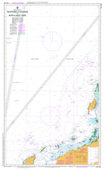
AUS 328
Montebello Islands To North West Cape
Please note that all charts are nominally folded in half for storage and handling as per the marine industries standard.
If you require an unfolded copy (ie: flat for framing), please select Flat Paper, and we will organise a special print service to accomodate your request.
Description
This official Nautical Chart is produced by the Australian Hydrographic Office, and corrected fortnightly to 'Notice to Marines' by Cairns Charts & Maps. This ensures it remains compliance with Safety of Navigation requirements. This marine chart, or 'sea map', is primarily produced to support the safe navigation of commercial shipping through Australian, Papua New Guinea and Solomon Island waters.
Nautical charts depict the seabed, or bathymetry, using a variety of colours to shade the depth regions. Darker blues indicate shallower water, while light blues and white indicate deeper water. A chart will also show continuous contour lines (at varying intervals depending on the scale of the chart), 'spot depths' across the whole area, as well as different symbols indicating wrecks, shallow rocks and dangers, as well as details on lights, light houses, tides and currents.
For extensive detail on the symbology of nautical charts, the Symbols and Abbreviations used on Admiralty Charts is the definitive reference.
Montebello Saddle Montebello Trough Tryal Rocks Exmouth Harold E Holt Naval Communication Station Onslow 10 Mile Pool 4 Mile Creek 5 Mile Creek 5 Mile Pool 5 Mile Well 7 Mile Claypan 7 Mile Dams 9 Mile Pool Aden Cove Airlie Island Alpha Island Ant Point Ashburton Island Ashburton Road Atriplex Island Attlee Point Australind Shoal Babjarrimannos Bandicoot Bay Banksia Island Baresand Point Barney Well Barrigoombar Claypan Barrigoombar Well Barrow Island Barrow Island Aerodrom Barrow Island Marine Park Barrow Island Nature Reserve Barrow Island Shoals Baylis Patches Beadon Bay Beadon Creek Beadon Point Bear Hill Beaufortia Island Beryl Reef Bessieres Island Big John Well Biggada Creek Birthday Island Black Ledge Bloodwood Island Bluebell Island Boab Island Boodie Island Boomerang Island Boronia Island Bowers Ledge Brand Park Brandy Bay Brewis Reef Brooke Island Brown Island Buffalo Hill Bundegi Coastal Park Bundegi Inner Reef Bundegi Outer Reef Burnbunman Flat Caladenia Island Cane River Cape Don Shoal Cape Dupuy Cape Malouet Cape Poivre Capparis Island Carattis Carnation Island Carraweela Well Casuarina Point Catchment Tank Catchment Well Chartreuse Bay Cheedawah Bore Cheedawah Claypan Channel Rock Chinty Creek Chinty Dam Chinty Pool Chinty Well Chianti Bay Chugori Rockhole Claret Bay Claret Cove Combe Reef Concrete Well Coolgra Point Cootamungra Well Corkwood Islands Cormorant Island Corridor Bore Crocus Island Cullen Park Cumboo Waterhole Curlew Bank Dailey Shoal Darcy Ridge Darkies Well Davis Well Direction Island Donald River Double Island Dove Point Drosera Island Dryandra Island Dunes Eagles Nest Entrance Point Euphorbia Island Exmouth Boat Harbour Exmouth District High School Exmouth Golf Club Exmouth Hospital Exmouth Reef Fairway Reef Fairy Tern Island False Island False Island Point Flacourt Bay Flat Island Flinders Shoal Fly Island Frankenia Island Frankland Well Freshwater Well Gardenia Island Glennie Patches Gnandaroo Island Gnandaroo Island Nature Reserve Goodenia Island Gorgon Patch Gravel Banks Harold E Holt Naval Communications Stn Hastings Shoal Hayman Rock Haynes Peninsula Helby Bank Herald Reef Hermite Island Hibbertia Island Hibiscus Island Hood Reef Hooley Creek Horseshoe Lagoon Hovea Island Inner North West Patch Ipomoea Island Jacks Bore Jamie Well Jarrah Islands Jasmine Islands Jims Beach Johnson Oval Jonquil Island Junction Well Jurabi Coastal Park Jurabi Point Kapok Well Karara Island Karri Islands Kennedia Island Kingcup Island Kingia Island Koobooroo Sports Oval Koolinda Patch Kuburu Well Kunzea Island Large Island Latitude Point Laurance Retirement Village Lefroy Bicentennial Park Lightfoot Reef Lighthouse Bay Lighthouse Hill Little Rocky Island Little Rocky Island Nature Reserve Little Shoals Locker Island Locker Island Nature Reserve Locker Point Locker Reef Lost Well Man On Rock Islet Mangrove Islands Mangrove Passage Manicom Bank Marri Islands Mary Anne Group Mary Anne Island Mary Anne Passage Mary Anne Passage Light Mary Anne Reef Mattress Point Mccann Well Melaleuca Island Melon Well Meredith Stephens Circuit Metters Bore Middle Island Middle Mangrove Island Miles Shoal Mistletoe Island Montebello Islands Moresby Shoals Moselle Bay Mount Athol Muiron Islands Mulga Islands Mungaroo Bore Mungaroo Pool Mungaroo Tank Mushroom Island Nannareena Well Nares Rock Niblett Oval Noonie Well North East 10 Mile Dam North East Twin Island North Island North Muiron Island North West Cape North West Cape Light North West Island North West Reef Noualla Community Observation Island Old Shed Well One Tree Well Onslow Aerodrome Onslow District Hospital Onslow Primary School Otway Reef Outer North West Patch Outtrim Patches Overhanging Rock Oyster Rock Palmerston Point Palms Well Paltridge Memorial Centre Pap Hill Parakeelya Island Parkes Reef Paroo Shoal Pasco Island Patersonia Island Payne Pass Peach Tree Bore Peak Island Pearl Reef Peedamulla Peedamulla Outcamp Penguin Bank Peters Well Picul Claypan Pindalla Creek Point Murat Poivre Reef Primrose Island Prince Island Ptilotus Island Richardson Shoal Ripple Shoals Rivoli Islands Rocky Islands Rocky Point Roller Shoal Rosily Islands Rosily Shoals Round Island Rum Cove S.S. Mildura Wreck Sack Bay Saddle Hill Saladin Shoal Santalum Island Santo Rock Serrurier Island Serrurier Island Nature Reserve Sesbania Island Shark Point Sherry Lagoon Snakewood Island Snapper Park Snappy Gum Island Solanum Island Somerville Island South End South Island South Muiron Island South West Patch South West Twin Island Speckled Hill Spider Reef Spinifex Island Stark Well Stokes Point Stylidium Island Sultan Reef Sunday Island Sunrise Beach Sunset Beach Surf Point Swainsona Island Table Island Talanjee Oval Tantabiddi Tantabiddi Creek Tantabiddi Passage Tantabiddi Well Taunton Reef Telegraph Bore Terminal Creek Terry Bore Thalanyji Oval The Bombie The Chair The Ledge Thevenard Island Thevenard Island Nature Reserve Tiger Hill Tongue Shoal Tony Keenan Courts Torpedo Bay Tortoise Island Tower Zero Town Beach Town Point Trap Reef Tringa Rock Triodia Island Tubridgi Point Tubridgi Reef Turtle Bay Turtle Lagoon Twin Islands Urala Urala Creek Victor Island Vigilant Passage Vlamingh Head Vlamingh Head Lighthouse Vlf Bay WA2001 Federation Park Wallaroo Waterhole Walleroo Well Wapet Camp Wapet Landing Ward Reef Web Reef Weeks Shoal Wellawarran Pool West Bay West Island West Reef Whites Beach Whitlock Cove Whittakers Well Wilbatharra Dam Wilbatharra Well Wild Wave Lagoon Wyloo Dam Wyloo Pool Wyloo Well Y Island Yammadery Creek Yammadery Island Yardi River Yardie Homestead Caravan Park Yardie Landing Bridled Island Double Islet Stakes Point Pasco Islet Barrow Island Shoal Large Islet Mary Anne Islands Mary Ann Group West Islet False Islet Saladin Marine Terminal Port Weld Little Rocky Islet Naples Rock Wilds Island North-east Twin Islet South-west Twin Islet Anchor Island Direction Islet Mary Ann Point Mary Anne Point Tortoise Islet Ashburton Islet Wallaroc Wells Peak Islet Flat Islet Long Island Table Islet Outrim Patches Outer Northwest Patch Inner Northwest Patch Round Islet Tongue Shoals Mookridi Well Ashburton River Curlew River Sunday Islet Old Onslow Locker Islet Observation Islet Ningola Curinana Glenroy Fly Islet Vlaming Head Point Locker Seven Mile Dams Point Murat Wharf Cape Well Paynes Pass Bundegi Reef Rocky Islets Yardie Creek Kudumurra Well Neds Well Cumboo Well Bare Hill Mungaroo Well Eva Island Eva Islet Tantabiddy Well Kubura Well McCanns Well Eddles Bore