
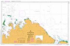
AUS 318
Pelican Island To Penguin Shoal
Please note that all charts are nominally folded in half for storage and handling as per the marine industries standard.
If you require an unfolded copy (ie: flat for framing), please select Flat Paper, and we will organise a special print service to accomodate your request.
Description
This official Nautical Chart is produced by the Australian Hydrographic Office, and corrected fortnightly to 'Notice to Marines' by Cairns Charts & Maps. This ensures it remains compliance with Safety of Navigation requirements. This marine chart, or 'sea map', is primarily produced to support the safe navigation of commercial shipping through Australian, Papua New Guinea and Solomon Island waters.
Nautical charts depict the seabed, or bathymetry, using a variety of colours to shade the depth regions. Darker blues indicate shallower water, while light blues and white indicate deeper water. A chart will also show continuous contour lines (at varying intervals depending on the scale of the chart), 'spot depths' across the whole area, as well as different symbols indicating wrecks, shallow rocks and dangers, as well as details on lights, light houses, tides and currents.
For extensive detail on the symbology of nautical charts, the Symbols and Abbreviations used on Admiralty Charts is the definitive reference.
Holothuria Banks Bonaparte Basin Bonaparte Depression Bonaparte Gulf Basin Sahul Shelf Kalumburu Admiralty Gulf Airfield Swamp Andrew Creek Anjo Cove Anjo Hill Anjo Peninsula Anjo Point Aragoon Atlantis Bay August Point Aunt Island Bare Hill Barton Plain Barton Plains Barton River Bassett-Smith Shoal Beauty Point Bedinbai Berkeley River Berthoud Island Bertram Cove Beta Creek Bigge Point Bignell Island Binghi Rocks Bird Island Bishop Rocks Bluff Point Boomerang Yard Borda Island Bougainville Peninsula Bougainville Reef Branch Banks Bream Ledge Bruce Creek Buckle Head Bulldust Yard Bundilee Camp Creek Campbell Range Cape Bernier Cape Bougainville Cape Domett Cape Dussejour Cape Londonderry Cape Rulhieres Cape St Lambert Cape Talbot Cape Whiskey Carlia Island Carronade Island Carson River Casuarina Creek Cawston Hill Centre Rock Charity Hill Circular Cove Cliffy Point Cole Creek Collison Range Combe Rock Cone Hill Cone Mountain Coondillah Creek Corneille Island Cowan Patches Cracticus Falls Crystal Creek Crystal Head Curran Point De Lancourt River Deep Bay Dome Hill Dominic Creek Doongan Double Hammock Drysdale River Drysdale River National Park Dulcis Falls Dysphania Gorge East Governor Island East Holothuria Reef Eclipse Hill Eclipse Hill Island Eclipse Islands Eeryoo Elbow Point Elsie Island Encounter Cove Entrance Shoal Eric Island Evelyn Island Eyre Reef Face Point Faith Hill False Mouths of the Ord Faraway Bay Fathom Rock Fenelon Island Fenelon Passage Finches Creek Fish Rock Flat Island Fly Point Forest Creek Forrest Rock Freshwater Bay Froggart Island Fury Rock Gabriel Island Galaxy Swamp Galley Point Geranium Harbour Geranium Islands Gibson Point Glider Gorge Glycosmis Bay Gonai Governor Islands Guy Point Hat Point Hecla Island Helby River Henry Reef Hill Point Honeymoon Beach Community Hope Hill Hunch Hill Ian Bay Ila Point Inner King Shoal Institut Islands Ivy Rock Jar Island Jiringgur Johnson Creek Jones Island Jooroo Ridge Joseph Bonaparte Gulf Judjamoorie Pool July Point June Point Kalumburu Aerodrome Kalumburu Community Kalumburu Mission Kalumburu Remote Community School Kandiwal Community Kanggurryu Island Kidney Island Kim Island Kimberley Coastal Camp King Edward River King George Falls King George River King Harman Point King Shoals Kingsmill Islands Klausmann Creek Koojarra Shoal Koolama Bay Kuntjumal Kutangari Island Lacrosse Island Lafontaine Island Lagrange Island Langoor Hill Larriman Yard Larryoo Lauwa Creek Lawley River Lee Rock Lesueur Island Long Island Long Reef Longini Loonjool Creek Lory Rock Louis Islands Low Island Low Point Low Rocks Low Rocks Nature Reserve Lyne River Macgregor Point Mackenzie Anchorage Maia Cove Majun Malcolm Island Malinjar Mama Hill Mangarr Mary Island Mcdonald Creek Medusa Banks Meealoyoo Hill Merrinjie Mertens Creek Mertens Falls Middle King Shoal Middle Osborn Island Middle Rock Milyoonga Mindjau Creek Mission Bay Mission Cove Mission Rocks Mitchell Falls Mitchell Plateau Moiyoo Creek Moliere Island Monger Creek Mongonai Creek Monorromboora Hill Montesquieu Islands Mool Mool Lagoon Moon Rock Moondoalnee Moongool Gorge Moonlight Yard Moorello Morgan River Mount Burns Mount Carty Mount Casuarina Mount Connelly Mount Connor Mount Keating Mount Leeming Mount Mcmillan Mount Nicholls Mount Reid Mushroom Rocks Myola Bluff Myres Island Myrmidon Ledge Napier Broome Bay Neewalara Point Ngalawaree Nglayu Island Ngoollalah Creek Nixson Point Noachitty Rapids Noolawayoo Creek North Eclipse Island North Rock Noseda Creek Nymphaea Creek Obstruction Hill Oliver Island Ooraro Hill Orchid Creek Osborn Islands Otway Bank Outer King Shoal Oyster Rock Oyster Rock Passage Pago Palmoondoora Palmoondoora Creek Pangoor Pangoor Creek Parndia Creek Parry Harbour Parry Island Pauline Bay Pearl Shoal Pelican Island Pelican Island Nature Reserve Penguin Deeps Penguin Shoal Petrogale Gorge Petrophassa Creek Pickering Point Pim Hill Placid Creek Planigale Creek Ponai Creek Poompangala Hill Port Warrender Pronga-Marie Creek Putairta Hill Racine Island Rail Creek Red Bluff Red Island Reveley Island Robin Gully Rocky Cove Rocky Island Rocky Reef Rosendo Creek Rothery Reef Sand Island Sandy Island Schizaea Creek Scorpion Island Scorpion Point Seaflower Bay Seaplane Bay Selsea Bill Seppelt Range September Point Shakespeare Hill Shark Rock Sharp Peak Sharp Point Sir Frederick Hills Sir Graham Moore Island Sir Graham Moore Islands Solea Falls South West Osborn Island Steamer Rock Steep Head Island Sterna Island Stewart Islands Surveyors Pool Swider Creek Symons Point Table Hill Tait Bank Tancred Bank Tate Point The Needles Theda Thurburn Bluff Thurburn Hill Tidepole Hill Tilwillie Pool Timor Sea Tingun Creek Troughton Island Troughton Island Aerodrome Troughton Passage Truscott Airbase Truscott-Mungalalu Aerodrome Tucker Bank Turtle Bay Ubach Creek Uncle Island Vaia Point Vancouver Point Vansittart Bay Wade Creek Wallis Peak Walmesly Bay Waloobanbeningai Walsh Point Wanan Creek Waneenee Waratah Shoal Warn Rock Warrender Warrender Hill Wells Patches West Bay West Bluff West Governor Island West Holothuria Reef West Rock Westwood Creek White Island White Stone Point Wollangooyoo Pool Womerah Bay Wonjarring Woonjah Creek Woppinbie Creek Yinaringgai Creek Yoorawai Billabong Young Creek Holothuria Reefs Stewart Islets Guichen Reef Troughton Islet Jones Islet Koojarra Island Lesueur Islet Sand Islet Red Islet Eclipse Archipelago Governor Islets Hecla Islet Louis Islets Bird Islet Oliver Islet Rocky Islet Pago Mission Drysdale River Mission Station Flat Islet Jar Islet White Islet North Island Water Island Elsie Islet Oomari Longini Landing Eric Islet Oorara Hill Poomrangala Hill Caloombooroo Mission Osborne Islands Cape Saint Lambert Parry Islet Slatey Creek Aunt Islet Uncle Islet Walmesley Bay Walmsley Bay Steep Head Mitchell River Mac Gregor Point Meduses Banks Lowley River Mount McMillan Langoar Hill Pelican Islet Mitchell Plateau Airfield Pangoar Cape Dommett Myrmidon Rock