
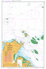
AUS 292
Wyborn Reef To Twin Island
Please note that all charts are nominally folded in half for storage and handling as per the marine industries standard.
If you require an unfolded copy (ie: flat for framing), please select Flat Paper, and we will organise a special print service to accomodate your request.
Description
This official Nautical Chart is produced by the Australian Hydrographic Office, and corrected fortnightly to 'Notice to Marines' by Cairns Charts & Maps. This ensures it remains compliance with Safety of Navigation requirements. This marine chart, or 'sea map', is primarily produced to support the safe navigation of commercial shipping through Australian, Papua New Guinea and Solomon Island waters.
Nautical charts depict the seabed, or bathymetry, using a variety of colours to shade the depth regions. Darker blues indicate shallower water, while light blues and white indicate deeper water. A chart will also show continuous contour lines (at varying intervals depending on the scale of the chart), 'spot depths' across the whole area, as well as different symbols indicating wrecks, shallow rocks and dangers, as well as details on lights, light houses, tides and currents.
For extensive detail on the symbology of nautical charts, the Symbols and Abbreviations used on Admiralty Charts is the definitive reference.
Ackers Shoal Adolphus Adolphus Channel Akone Islet Albany Island Albany Passage Albany Rock Alpha Rock Archer Rock Arethusa Point Ariel Bank Bay Point Beagle Rock Big Creek Blackwood Bay Bowden Rock Mount Bremer Brewis Island Lake Bronto Bungaree Shoals Bush Islet Cambridge Point Campbell Reef Carnegie Range Chandogoo Point Chinera Creek Cliffy Point Cody Creek Cody Hill Congora Beach Lake Congora Dutfield Rock East Strait Island Eborac Island Edwards Rock Evans Bay Evans Point Filmer Fishbone Creek Fly Point Four Fathom Patches Freshwater Bay Galloways Hill Harrington Reef Harrington Shoal Harvey Rocks Herring Creek High Island Hovell Shoal Ibis Reefs Ida Island Jackey Jackey Airfield Jackey Jackey Creek Johnson Islet Keatinge Islet Kennedy Inlet Kilbie Beach Kirkcaldie Reef Lacey Island Laradeenya Creek Little Adolphus Island Little Roko Island Lockerbie Mai Islet Markilug Islet Mew River Mid Rock Middle Brother Mona Rock Morilug Islet Mount Adolphus Island Muddy Bay Murangi Islet Nanthau Beach Narau Beach Newcastle Bay Nicklin Islet North Brother North Ledge Paterson Creek Mount Paterson Peak Hill Peak Point Piara Pioneer Bay Pitt Rock Polo Creek Possession Island Punsand Bay Quetta Rock Reeves Shoal Reid Rock Rescue Rock Roko Island Mount Roma Saldogoo Beach Lake Saldogoo Salter Island Sana Rock Lake Sapaginya Sextant Rock Seymour Shallow Bay Sharp Point Shortland Reef Somerset South Brother South Ledge Tetley Island Tree Island Trochus Island Turtle Head Turtle Head Island Turtle Island Twin Island Ulfa Rock Ulrica Point Vallack Point Vicary Bay Wasp Creek Lake Wicheura Wilson Creek Woomera Creek Wuwurrka Islet Wyborn Reef York Island Cape York Possession Island National Park Jardine River Torres Shire Punsand Forbes Head Dickey Point Pinnacle Peak North East Bluff Frederick Point Alfred Point Charlotte Point Ida Point Little Ida Island Osnaburg Point Somerset Point Somerset Bay Bishop Point Stover Bay Bamaga New Mapoon Umagico Beagle Rocks Double Island Nelgee Island Reeves Shoals Nigger Head Jardine Rock Nicklin Island Keatinge Island Mount Adolphus Islands Mount Adolphus Mori Blackwood Bank Morilug Morilug Island Dugong Island Johnson Island Akone Island Akone Point Bush Island Mid Brother Meggi-Damun Reef York Road Peaked Hill Carubaura Cape York Telegraph Station Fred Point Mai Island Paget Point Bedanug Tetley Islets Roonga Point Pabaju Seymour Point Kloster Point Albany Pass Port Albany Orpheus Point Lyons Point Roma Flats Wassel Island Wuwurrka Island Markilug Island Otuckano Creek Lockerie Paterson Hill Z Reef Y Reef X Reef Kennedy River Jacky Jacky Creek Kennedy Midola River OK Village