
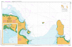
AUS 268
Approaches To Bowen
Please note that all charts are nominally folded in half for storage and handling as per the marine industries standard.
If you require an unfolded copy (ie: flat for framing), please select Flat Paper, and we will organise a special print service to accomodate your request.
Description
This official Nautical Chart is produced by the Australian Hydrographic Office, and corrected fortnightly to 'Notice to Marines' by Cairns Charts & Maps. This ensures it remains compliance with Safety of Navigation requirements. This marine chart, or 'sea map', is primarily produced to support the safe navigation of commercial shipping through Australian, Papua New Guinea and Solomon Island waters.
Nautical charts depict the seabed, or bathymetry, using a variety of colours to shade the depth regions. Darker blues indicate shallower water, while light blues and white indicate deeper water. A chart will also show continuous contour lines (at varying intervals depending on the scale of the chart), 'spot depths' across the whole area, as well as different symbols indicating wrecks, shallow rocks and dangers, as well as details on lights, light houses, tides and currents.
For extensive detail on the symbology of nautical charts, the Symbols and Abbreviations used on Admiralty Charts is the definitive reference.
Bowen Merinda Hideaway Bay Adelaide Point Alligator Lagoon Bells Waterhole Mount Bertha Black Currant Island Bluff Point Bona Bay Bootooloo Mount Bramston Brisk Bay Calton Hill Chinamans Rock Chyebassa Shoal Dalrymple Point Datum Rock Delta Port Denison Dingo Beach Don Don River Doughty Creek Duck Creek Durroburra Edgecumbe Heights Cape Edgecumbe Flagstaff Hill Gloucester Head Gloucester Island Gloucester Passage Cape Gloucester Gordon Creek Mount Gordon Hay Gully Herbert Heronvale Horseshoe Bay Kelsey Kings Beach Long Waterhole McCanes Bay Middle Hill Middle Island Mother Beddick Mount Nutt Waterholes Mullers Lagoon Murray Bay North Entrance North Head North Rock Mount Nutt Passage Islet Police Camp Creek Pring Queens Bay Queens Beach Rose Bay Sandy Creek Shoal Bay Shoalwater Bay Sinclair Head South Entrance South Head Stone Island The Green Swamp Thomas Island Walschs Crossing Wentworth Rocks Mount Williams Winter Shoal Yumbabullo Gloucester National Park Greys Bay Inveroona Inverncoona Mount Nuts Don Hill Mount Mother Beddick Alligator Lagoons Bowen Hill Town Hill Saltwater Creek Round Hill Point Shoal Water Bay Port of Bowen Passage Island Gloucester Pass