
AUS 262
Approaches To Cairns
Please note that all charts are nominally folded in half for storage and handling as per the marine industries standard.
If you require an unfolded copy (ie: flat for framing), please select Flat Paper, and we will organise a special print service to accomodate your request.
Description
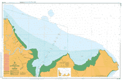
This official Nautical Chart is produced by the Australian Hydrographic Office, and corrected fortnightly to 'Notice to Marines' by Cairns Charts & Maps. This ensures it remains compliance with Safety of Navigation requirements. This marine chart, or 'sea map', is primarily produced to support the safe navigation of commercial shipping through Australian, Papua New Guinea and Solomon Island waters.
Nautical charts depict the seabed, or bathymetry, using a variety of colours to shade the depth regions. Darker blues indicate shallower water, while light blues and white indicate deeper water. A chart will also show continuous contour lines (at varying intervals depending on the scale of the chart), 'spot depths' across the whole area, as well as different symbols indicating wrecks, shallow rocks and dangers, as well as details on lights, light houses, tides and currents.
For extensive detail on the symbology of nautical charts, the Symbols and Abbreviations used on Admiralty Charts is the definitive reference.
Yarrabah Aeroglen Barr Creek Barron Beach Barron River Bessie Falls Bessie Point Brinsmead Gap Brown Bay Brown Creek Bullburra Beach Cairns Harbour Cairns North Casuarina Point Cowley Creek Ellie Point False Cape Fitzalan Creek George Creek Giangurra Cape Grafton Hamliffe Creek Kappa Creek King Beach Koombal Lily Creek Little Turtle Bay Lumley Hill Lyons Point Mick Creek Mission Bay Nares Palm Beach Redden Creek Richter Creek Rocky Island Rolling Bay Second Beach Stratford Siding Sturt Cove Sunny Bay Thomatis Creek Turtle Bay Whites Gap Mount Whitfield Wide Bay Yarrabah Beach Mount Yarrabah Yorkeys Creek Yorkeys Knob Yorkeys Point Anderson Street Conservation Park Mount Whitfield Conservation Park Machans Beach Holloways Beach Middle Creek Saltwater Creek Brinsmead Edge Hill Manoora Manunda Stratford Whitfield Smithfield Creek Holloway Beach Bulburra Beach Freshwater Cairns International Airport Cairns Little Barron River Gribble Point LittleTurtle Bay Yarrabah Aboriginal Community Stafford Point Nisbet Range Yarrabah Mission Grant Hill