
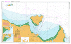
AUS 256
Cleveland Bay And Approaches
Please note that all charts are nominally folded in half for storage and handling as per the marine industries standard.
If you require an unfolded copy (ie: flat for framing), please select Flat Paper, and we will organise a special print service to accomodate your request.
Description
This official Nautical Chart is produced by the Australian Hydrographic Office, and corrected fortnightly to 'Notice to Marines' by Cairns Charts & Maps. This ensures it remains compliance with Safety of Navigation requirements. This marine chart, or 'sea map', is primarily produced to support the safe navigation of commercial shipping through Australian, Papua New Guinea and Solomon Island waters.
Nautical charts depict the seabed, or bathymetry, using a variety of colours to shade the depth regions. Darker blues indicate shallower water, while light blues and white indicate deeper water. A chart will also show continuous contour lines (at varying intervals depending on the scale of the chart), 'spot depths' across the whole area, as well as different symbols indicating wrecks, shallow rocks and dangers, as well as details on lights, light houses, tides and currents.
For extensive detail on the symbology of nautical charts, the Symbols and Abbreviations used on Admiralty Charts is the definitive reference.
Carinya Springvale Mountain View Glenborough Glen Retreat Kataughal Bullooloola Arcadia Bay Bushland Beach Deeragun Horseshoe Bay Jensen Mount Low Nelly Bay Pallarenda Picnic Bay Saunders Beach Townsville Alice River Alick Creek Alligator Creek Alma Bay Alma Creek Althaus Creek Arthur Bay Bald Islet Balding Bay Bare Islet Bay Rock Bee Ran Black River Mount Black Bluewater Beach Bluewater Creek Bohle Bohle River Mount Bohle Bolger Bay Bramble Rock Bray Islet Bremner Point Bright Point Burdekin Rock Butlers Creek Canal Creek Castle Hill Chinaman Creek Chunda Bay Cleveland Bay Cape Cleveland Mount Cleveland Cobarra Cockle Bay Cocoa Creek Coonambelah Crocodile Creek Deep Creek Duck Creek Eastern Breakwater Endeavour Creek Cape Ferguson Florence Bay Four Foot Rock Garbutt Geoffrey Bay Goondi Creek Gordon Creek Gorge Creek Gowrie Bay Gustav Creek Hawkings Point Healy Creek Herald Island Huntingfield Bay Jimmys Lookout Joyce Bay Kissing Point Kulburn Launs Beach Liver Point Log Creek Long Beach Lorne Reef Louisa Creek Mount Louisa Lovers Bay Low Creek Magazine Island Magnetic Magnetic Island Magnetic Island National Park Many Peaks Range Mount Marlow Martin Bluff Maud Bay Middle Reef Monkey Island National Creek Ned Lee Creek Nightjar Nobby Head Norris Bay Notch Peak Oonoonba Orchard Rocks Cape Pallarenda Paluma Shoals Paradise Bay Petersen Creek Purono Quealban Queens Road Radical Bay Rattlesnake Island Red Rock Bay Red Rock Point Retreat Creek Rocky Bay Rollingstone Bay Ross Creek Ross Island Ross River Rowes Bay Sailors Rock Salamander Reef Sandfly Creek Saunders Creek Mount Saunders Scrubby Creek Shelly Beach Shelly Creek Mount St John Stony Creek Stuart Creek Three Mile Creek Toolakea Townsville West Twenty Foot Rock Virago Shoal West Channel West Point Western Breakwater White Lady Rock White Rock White Rock Bay Whitfield Cove Wilson Bay Cape Woora Yabulu Yenoor Young Bay Cape Pallarenda Conservation Park Horseshoe Bay Lagoon Conservation Park Townsville Town Common Conservation Park Bolger Bay Conservation Park Toolakea Beach Aitkenvale Arcadia Beach Holm Belgian Gardens Bohle Plains Burdell Cosgrove Cranbrook Currajong Gulliver Heatley Hermit Park Idalia Kirwan Mundingburra Mysterton North Ward Pimlico Railway Estate Rangewood Rosslea Shaw Shelly Beach Townsville City South Townsville Town Common Townsville City Vincent West End Townsville City Hyde Park Bluewater Purona Bohle Creek Many Peak Range Rose Bay Red Cliff Point Platypus Channel Night jar Mount Saint John Melton Hill Townsville Harbour Flagstaff Hill Blind Creek Bare Rock Garbutt Station Garbutts Siding Cudtheringa Mount Cudtheringa Mount Gudtheringa Oonoobah