
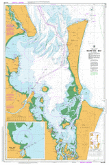
AUS 236
Moreton Bay
Please note that all charts are nominally folded in half for storage and handling as per the marine industries standard.
If you require an unfolded copy (ie: flat for framing), please select Flat Paper, and we will organise a special print service to accomodate your request.
Description
This official Nautical Chart is produced by the Australian Hydrographic Office, and corrected fortnightly to 'Notice to Marines' by Cairns Charts & Maps. This ensures it remains compliance with Safety of Navigation requirements. This marine chart, or 'sea map', is primarily produced to support the safe navigation of commercial shipping through Australian, Papua New Guinea and Solomon Island waters.
Nautical charts depict the seabed, or bathymetry, using a variety of colours to shade the depth regions. Darker blues indicate shallower water, while light blues and white indicate deeper water. A chart will also show continuous contour lines (at varying intervals depending on the scale of the chart), 'spot depths' across the whole area, as well as different symbols indicating wrecks, shallow rocks and dangers, as well as details on lights, light houses, tides and currents.
For extensive detail on the symbology of nautical charts, the Symbols and Abbreviations used on Admiralty Charts is the definitive reference.
Caloundra Beachmere Amity Point Bongaree Buderim Donnybrook Kawana Waters Maroochydore Mooloolaba Ningi Point Lookout Sandstone Point Sippy Downs Toorbul Woorim Adder Rock Alexandra Headland Alexandra Headland Beach Amity Ampol Siding Aquarium Passage Ascot Bald Point Banyo Battery Hill Bells Creek Bells Creek North Branch Bells Creek South Branch Big Sandhills Bindha Black Gutter Blue Hole Blue Lagoon Boat Passage Boat Rock Boggy Creek Boltons Ridge Boolong Bank Boondall Bramble Bay Bray Rock Braydon Beach Brennan Shoal Bribie Island Brisbane River Browns Gutter Buderim Mountain Bulcock Beach Bullock Creek Bulwer Bulwer Island Bulwer Valley Bunbubah Creek Bunour Cabbage Tree Creek Cabbage Tree Head Caloundra Head Campbell Point Mount Campbell Point Cartwright Castlereagh Point Central Banks Chain Banks Chambers Island Channel Island Chanuk Bair Chiggil Chiggil Clara Rock Clayfield Cape Cliff Clohertys Peninsula Clontarf Beach Clontarf Point Clunie Flats Comboyuro Point Cone Hill Coochin Creek Cooks Rock Coolooloo Passage Coondibah Creek Coondibah Lagoon Coonowrin Creek Coonungai Bank Cornmeal Creek Cowan Cowan Cowan Cowan Gully Cowan Cowan Point Crab Creek Currimundi Creek Cylinder Beach Cylinder Headland Days Gutter Deagon Deception Bay Deep Water Channel Deep Water Point Diagram Hills Dicky Beach Dingo Creek Doomben Downfall Creek Dowse Lagoon Dring Bank Drury Point Dune Rocks Dux Creek Eager Beach Eagers Creek Eagers Swamp East Bank East Channel East Knoll Egg Island Einbunpin Lagoon Elimbah Creek Erica Passage False Patch Finuge Passage First Ridge Fisherman Islands Fishermans Gutter Five Hills Flat Iron Flat Rock Flinders Reef Francis Channel Frasers Gutter Frenchmans Bay Frenchmans Beach Freshwater Creek Gallagher Point Garnet Gebelum Gibson Island Glass Mountain Creek Gneering Shoals Goat Island Godwin Beach Golden Beach Gonzales Beach Grants Creek Green Island Gun Ridge Halls Bay Halls Creek Hamilton Patches Hamilton Reach Hays Inlet Heath Island Hell Spit Henderson Rock Hendersons Gutter Hendra Hixson Banks Holly Spur Hope Banks Howard Range Humpybong Creek Hussey Creek Hutchison Shoal Hutchison Peak Inner Freeman Channel Irwin Creek Jacksons Creek Jason Beach Jessie Peak Jubilee Creek Juno Point Kedron Brook Kianga Channel Kidney Ridge Kings Beach Kooringal Kounungai Lamerough Creek Landers Pocket Drain Lindum Little Goat Island Little Sandhills Long Island Luggage Point Lytton Hill Lytton Reach Maglaglan Ridge Main Channel Margate Beach Maroochy River Maroochydore Beach Maroom Bank Maroom Hole Mays Hole Meeandah Meridan Plains Mermaid Lagoon Middle Banks Mirapool Islands Mission Point Moffat Beach Moffat Head Monash Gully Mooloolaba Beach Mooloolaba Harbour Mooloolah River Moreton Banks Moreton Bay Moreton Island Moreton Island National Park Cape Moreton Mount Cotton Reach Mountain Creek Mud Island Myrtletown Nashville Ningi Creek Ningi Island Noogoon North Bank North Boondall North East Channel North Gorge North Point North Reef North Spit North West Channel Northgate Nudgee Nudgee Beach Nudgee Creek Nudgee Waterhole Nundah Nundah Creek Osbourne Point Otter Rock Outer Freeman Channel Oyster Point Pandanus Beach Parker Island Pearl Channel Pelican Bank Picnic Point Pimple Pincushion Island Pinkenba Plugges Plateau Poverty Creek Pumicestone Channel Pumicestone Creek Queens Beach Queens Beach North Queens Beach South Raper Shoal Redcliffe Redcliffe Beach Redcliffe Point Reeders Point Ridge Shoal Roberts Shoal Rocky Hill Rocky Point Round Hill Rous Channel Russels Top Salamander Bank Saltwater Creek Sandgate Sandy Peak Sandy Point Reach Scarborough Beach Scarborough Boat Harbour Scarborough Point Schulz Canal Scotts Point Scotts Point Beach Second Ridge Serpentine Creek Shag Rock Shark Spit Shelly Beach Sholl Bank Shorncliffe Shrapnel Gully Sippy Creek Skirmish Banks Skirmish Passage Skirmish Point Smith Smith Peak Smith Rock Snake Spur South Bank South Headland South Passage South Point South Reef South Tangalooma Road South West Spit Sovereign Beach Spitfire Banks Spitfire Beach Palmview Conservation Park St Helena Island Storm Mountain Sunshine Suttons Beach Sylvan Beach Tabilbulla Tallallebela Tangalooma Patch Tangalooma Tangalooma Point Tangalooma Road Telegraph Gully Mount Tempest The Desert The Divide The Nek Third Ridge Thooloora Island Tiffin Tingal Hill Toombul Toompani Beach Toorbul Point Tooway Creek Toulkerrie Triangle Tuckers Creek Tungewa Turners Camp Island Umbounba Venus Banks Virginia Walkers Ridge Wallum Creek Wanga Wallen Bank Warragamba Bank Warrajamba Beach Welsby Lagoon West Banks Western Banks Whale Rock Whinstanes Whites Lookout Whyte Island Wild Banks Wisemans Lookout Woody Bay Woody Point Woody Point Beach Wynnum Wynnum Creek Wynnum North Yellow Patch Yule Bank Yule Road Zillman Waterholes Zion Hill Garnet Rock Tripcony Bight The Skids North Banks North Channel Cotton Tree Beachmere Conservation Park Buckleys Hole Conservation Park Bribie Island National Park Currimundi Lake Conservation Park Fort Lytton National Park Hays Inlet Conservation Park One Hays Inlet Conservation Park Two St Helena Island National Park Mooloolah River National Park Bullock Creek Conservation Park Cannery Creek Old Bar Cutting Brighton Cape Moreton Conservation Park Mud Island Conservation Park Quarantine Flats Reach Lytton Port of Brisbane Ascot Brisbane City Eagle Farm Hamilton Jeays Reef Caloundra Conservation Park Ningi Creek Conservation Park Aroona Birtinya Bokarina Bribie Island North Buddina Caloundra West Currimundi Little Mountain Minyama Palmview Parrearra Pelican Waters Shelly Beach Caloundra City Warana Wurtulla Kuluin Kippa-Ring Margate Meldale Newport Rothwell Banksia Beach Bellara Clontarf Moreton Bay Regional Council Scarborough Welsby White Patch Gneering Shoal Alexandra Head Alexandra-Mooloolaba Raper Point Ferguson Spit Dickey Beach Wickham Point Bell Creek Howe Channel Glass House Mountain Creek Wilds Bank Wilds Banks Outer Freeman Channnel Bribie View Gallagher Point Spitfire Bank Pumice Stone Strait Freeman Channel Parrot Island Ridge Tree Hill Old Bribie Spitfire Channel Ducks Creek Shields Point Skirmish Pass Bulwer Cottages Comboyro Point Yule Roads Maclaglan Ridge Diagram Hill Bribie Skirmish Swamp Elbow Plugge Plateau Russells Top Russell Top Cowan Gully Hill Six Hundred Leading Hill Shoal Bank Tangaluma Road Tangaluma Point Reef Point Four Fathom Bank Middle Bank South Tangaluma Road Scott Point Hayes Inlet Pine River North Pine River Brisbane Road Brisbane Roads Coonungal Bank Cowards Island Outer Bar Reach Outer Bar Cutting Clohertya Peninsula Crab Tree Station Jackson Creek Cribb Island Koopa Channel East Banks Hamilton Point Inner Bar Cutting Fisherman Point Dredge Spoil Bank Bishop Island Patrick Wharf Rufus King Myrtle Saint Helena Island Luggage Point Cutting Uniacke Point Lower Reach Sandy Point White Island North Gate Junction Pelican Banks Reach Pelican Bank Cutting Lytton Rocks Reach Lytton Rocks Cutting Ampol Wharf Kedron Kedron Brook Upper Lytton Cutting Bulwer Wall Lytton Cutting Swing Basin Swing Basin Reach Reformatory Hill Shifting Sand Island Boat Rocks Green Islet Lytton Wall Rainbow Channel Eagle Farm Reach Pinkenba Cutting Eagle Farm Flats Cutting Doboy Wall Parker Island Wall Coxen Point Coxen Point Wall