
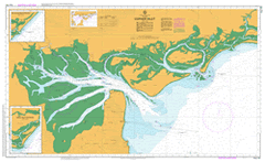
AUS 181
Corner Inlet
Please note that all charts are nominally folded in half for storage and handling as per the marine industries standard.
If you require an unfolded copy (ie: flat for framing), please select Flat Paper, and we will organise a special print service to accomodate your request.
Description
This official Nautical Chart is produced by the Australian Hydrographic Office, and corrected fortnightly to 'Notice to Marines' by Cairns Charts & Maps. This ensures it remains compliance with Safety of Navigation requirements. This marine chart, or 'sea map', is primarily produced to support the safe navigation of commercial shipping through Australian, Papua New Guinea and Solomon Island waters.
Nautical charts depict the seabed, or bathymetry, using a variety of colours to shade the depth regions. Darker blues indicate shallower water, while light blues and white indicate deeper water. A chart will also show continuous contour lines (at varying intervals depending on the scale of the chart), 'spot depths' across the whole area, as well as different symbols indicating wrecks, shallow rocks and dangers, as well as details on lights, light houses, tides and currents.
For extensive detail on the symbology of nautical charts, the Symbols and Abbreviations used on Admiralty Charts is the definitive reference.
Foster Port Albert Port Welshpool Toora Port Franklin Robertsons Beach Welshpool Manns Beach Barry Beach Agnes Falls The Little River Alberton East Alberton Post Office Alberton Primary School Alberton Recreation Reserve Alberton West Bale of Straw Bar Banks Barry Beach Channel Barrys Creek Barry Point Barrys Hill Bass Strait Bennison Bennison Channel Bennisons Creek Bennison Creek Channel Bennison Island Bennison Spit Buoy Bentley Harbour Bentley Point Biddies Cove Dog Island Big Hummock Blackberry Bight Blackwood Creek Boat Harbour Channel Bobs Island Boggy Bight Boney Bridge Creek Bullock Bullock Horn Islet Bullock Island Calf Island Canoe Point Chinaman Beach Chinamans Creek Chinamans Knob Chinamans Long Beach Chinaman Swamp Chinamans Point Chitts Creek Christopher Robinson Walking Track Clonmel Banks Clonmel Banks Light Clonmel Island Clonmel Sands Clonmel Spit Clump Channel Clumps Gutter Cobbler Spit Cobblers Bank Corner Inlet Corner Island Cow Creek Cow Swamp Crane Bay Cyril Island Deep Creek Denmans Point Dog Island Point Doughboy Channel Martins Island Drift Walking Track Drum Creek Earthquake Island Drum Island Rear Light Duck Point Little Channel Earthquake Creek East Scrubby Island Entrance Point Eye Swamp Farmers Channel Fishermans Creek Foster Beach Foster Fire Station Foster High School Foster Police Station Foster Post Office Foster Primary School Foster Public Hall Foster Recreation Reserve Foster Telephone Exchange Franklyn Channel Franklin River Franklin River Channel Franklin Spit Buoy Freshwater Cove Gelliondale Granite Island Gulf Gutter Gumboot Flat Hedley Fire Station Hedley Primary School Hedley Telephone Exchange Hookly Gutter Horn Island Howdens Gutter Hunter Island Hunter Point Jephson Island John Crew Memorial Picnic Area Johnny Souey Cove Johnny Souey Point Johnny Souey Track Kangaroo Clump Shallow Inlet East Kewita Creek La Trobe Buoy Lamonts Creek Lance Moon Park Lawson Beach Lays Hill Lewis Channel Lighthouse Point Lipscombe Point Little Dog Island Little Snake Bluff Little Snake Bluff Beacon Little Snake Island Long Flats Long Island Lower Barry Creek Camping Area Magazine Gutter Magazine Point Mangrove Island McMillan Bay Middle Channel Middle Ground Smokehouse Gutter Midge Channel Millers Landing Monash Inlet Mop Island Mount Hunter Mount Margaret Round Backed Hill Mount Singapore Muddy Creek Neils Creek New Zealand Hill Nichols Point Nine Mile Creek Nooramunga Faunal Reserve Old Man Clumps Old Port Channel Old Settlement Beach One Tree Island One Tree Spit Pebble Creek Pelican Channel Pelican Island Pelican Island Light Pelican Swamp Picnic Beach Point Singapore Poor Fellow Me Creek Port Albert Channel Shallow Inlet West Port Albert Fire Station Port Albert Front Light Port Albert Primary School Port Albert Public Hall Port Franklin Public Hall Port Welshpool Post Office Possum Island North Possum Island South Rabbit Inlet Rankins Hill Red Bluff Beach Red Swamp Rescue Island Richards Creek Rifle Range Waterhole Roberts Island Roberts Point Rutters Jetty Salmon Creek Sand Island Scrubby Island Secret Spit Shady Creek Shag Island Shag Swamp Shallow Bight Sheep Island Shelter Cove Shoal Inlet Silcocks Hill Slades Hill Smokehouse Point Snaggy Cove Snaggy Gutter Snaggy Island South Channel Snake Island South Gippsland Hospital South Gippsland Secondary College Spec Island Stannaways Gutter Stockyard Channel Stockyard Creek Stockyard Hill Sugarloaf Sunday Island Sunday Island Channel Swan Bay Swashway Tarra Channel Tarraville Tarraville Primary School Tarraville Recreation Reserve Telegraph Swamp Thatchers Bank The Big Hole The Canal The Gulf The Horse Shoe Three Mile Beach Three Mile Point Tidal Creek Tin Mine Cove Tin Mine Creek Tin Mine Hill Tin Mine Point Toora Beach Toora Channel Toora Fire Station Toora Police Station Toora Post Office Toora Primary School Toora Public Hall Townsend Point Townsends Point Tree Bullock Waterhole Turnip Patch Waddy Island Warreen Welshpool Aerodrome Welshpool Fire Station Welshpool Jetty Welshpool Pier Welshpool Post Office Welshpool Primary School Welshpool Public Hall Welshpool Recreation Reserve Welshpool Telephone Exchange Western Inlet Whale Rock White Dog Point White Rock White Swamp Wilsons Paddock Wonga Wonga Wonga Wonga South Yanakie Yanakie Beach Yanakie Fire Station Yanakie Isthmus Yanakie Public Hall Yanakie South Mine Creek Attercliffe Cornelian Creek Woorarra East Kays Hill Alberton Hazel Park Hedley Cypress Grove Jack River Tarra River Tarra Tarra River Albert River Port Tranklin Agnes River Agnes Kate Kearneys Entrance Port Albert Entrance Latrobe Island Doughboy Island Corner Basin Franklin Channel Chinamans Beach Benison Island