
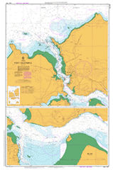
AUS 167
Port Dalrymple
Please note that all charts are nominally folded in half for storage and handling as per the marine industries standard.
If you require an unfolded copy (ie: flat for framing), please select Flat Paper, and we will organise a special print service to accomodate your request.
Description
This official Nautical Chart is produced by the Australian Hydrographic Office, and corrected fortnightly to 'Notice to Marines' by Cairns Charts & Maps. This ensures it remains compliance with Safety of Navigation requirements. This marine chart, or 'sea map', is primarily produced to support the safe navigation of commercial shipping through Australian, Papua New Guinea and Solomon Island waters.
Nautical charts depict the seabed, or bathymetry, using a variety of colours to shade the depth regions. Darker blues indicate shallower water, while light blues and white indicate deeper water. A chart will also show continuous contour lines (at varying intervals depending on the scale of the chart), 'spot depths' across the whole area, as well as different symbols indicating wrecks, shallow rocks and dangers, as well as details on lights, light houses, tides and currents.
For extensive detail on the symbology of nautical charts, the Symbols and Abbreviations used on Admiralty Charts is the definitive reference.
Banyanda Forest Gate George Town Low Head Kelso Anchor Point Dotterel Point Dotterel Reef East Beach Eastern Channel Arthurs Head Ashmans Point Barrel Rock Barrel Spit Beauty Point Bell Bay Bell Bay Station Bellbuoy Beach Black Reef Blue Gum Park Boats Crew Point Bombay Rock Boongala Reserve British Creek Bryants Bay Cimitiere Creek Cimitiere Plain Clarence Point Cordell Point Currong Reserve Deceitful Cove Donovans Bay Elbow Spit Elizabeth Park Examiner Rock Five Mile Bluff Four Mile Bluff Four Mile Creek Friend Point Greens Beach Greens Beach Conservation Area Greens Beach Golf Course Garden Island Garrow Rock George Town Conservation Area George Town Golf Course George Town Station George Town Sugarloaf Gibsons Beach Gordon Square Hebe Reef Honduras Bank Hospital Point Ilfraville Inspection Head Kelso Bay Killara Reserve Lagoon Bay Lagoon Beach Lauriston Reservoir Lawrences Bluff Long Flat Long Tom Reef Lovers Islets Low Head Conservation Area Low Head Historic Site Low Head Lighthouse Manduama Park Max Harris Memorial Reserve Middle Bank Middle Channel Middle Island Middle Point Monomeeth Reserve Mount George North West Bank Nudists Beach Orari Bank Pebble Beach Perrin Reserve Pilots Bay Pipeclay Bay Point Effingham Porpoise Rock Port Dalrymple Potato Hill Redbill Point Redbill Point Conservation Area Regent Square Saltpan Point Sandy Beach Sawyers Point Sea Hill Sea Reach Second Sands Shag Rock She Oak Point Shear Reef Shear Rock Simmons Mistake Slippers Hill Stockyard Hills Stone Quarry Bay The Buffalo Three Mile Bluff Toroa Patch Two Mile Reef Wentworth Hill West Arm West Arm Conservation Area West Reef Windmill Point Wolverine Shoal Yellow Rock York Cove York Creek York Town York Town Rivulet Yorktown Historic Site Beauty Point Wharf Bell Bay Wharf Big and Little Plain Boobyalla Bay Cimitiere Valley Comalco Wharf Coxs Bight Ferry Wharf First Little Beach Four Mile Creek Bridge George Town Lookout Inspection Head Wharf Mount Albany Mount Pelion North Head Oyster Banks Shoal Bay Soldiers Point Tanker Wharf Wybia Spit West Head Point Flinders River Tamar Penrabbel Tamar River Pilots Boat Harbour Boobyalla She-Oak Point Buffalo Hill Sugarloaf Georgetown Middle Arm Long Reach