
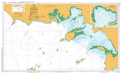
AUS 120
Approaches To Thevenard
Please note that all charts are nominally folded in half for storage and handling as per the marine industries standard.
If you require an unfolded copy (ie: flat for framing), please select Flat Paper, and we will organise a special print service to accomodate your request.
Description
This official Nautical Chart is produced by the Australian Hydrographic Office, and corrected fortnightly to 'Notice to Marines' by Cairns Charts & Maps. This ensures it remains compliance with Safety of Navigation requirements. This marine chart, or 'sea map', is primarily produced to support the safe navigation of commercial shipping through Australian, Papua New Guinea and Solomon Island waters.
Nautical charts depict the seabed, or bathymetry, using a variety of colours to shade the depth regions. Darker blues indicate shallower water, while light blues and white indicate deeper water. A chart will also show continuous contour lines (at varying intervals depending on the scale of the chart), 'spot depths' across the whole area, as well as different symbols indicating wrecks, shallow rocks and dangers, as well as details on lights, light houses, tides and currents.
For extensive detail on the symbology of nautical charts, the Symbols and Abbreviations used on Admiralty Charts is the definitive reference.
Ceduna Smoky Bay Hopefield Chillundie Beautiful Valley Tank Cantaby Hut Davenport Creek Well Charra Well Far West Aboriginal Sports Complex Laura Post Office Nunong Wingara Tank Laura Bay Tank Cape D'Estees Maltee Railway Station Ceduna Railway Station Pointe des Capucins Flinders Rock Far West Senior Citizens Village Daphne Rock Rocky Point McKenzie Ruins Worsnap Camp La Baleine Wangabina Low Point Ceduna Area School Charra Post Office Tonkin Oval Whittelby Point Ceduna Old Primary School Site Merghiny Waterhole Cootama Hut Denial Bay Tanks Koppitucka Rockholes Merghiny Well Wittelbee Point Murat Bay District Hospital Saddle Peak Point Kongwirra Hill Konomoola Ruins Bird Rock Merghiny Post Office Gliddon Reef Mount Younghusband Ceduna Lutheran School Cap Bon Fond The Cutting Koppitucka Waterhole Hundred of Bonython Petrel Bay Point Bell Conservation Park Nuyts Archipelago Marine Park Mary Pointe du Tisseran Ile Eugene La Rembarde Ile Talleyrand De Cres Bay Baie des Herissons Franklin Islands Ile Caroline Ile des Olives McKenzie Purdie Islands Ile Pauline Iles du Geographe Ile Richelieu Breakwater Island Eyre Island Le Pacifique Ceduna South Smooth Island Thevenard Post Office Derrick Landing Little Eyre Island Poverty Flat Tank Tiverleen Nuyts Archipelago Hundred of Bartlett Pointe des Bruans Mildooka Well Edeloa Well Ceduna Post Office Mildooka Lound Reef Iles St Pierre Ile Langles Charra Gascoigne Bay Bosanquet Bay La Navette Chillundie Well Isles of St Peter Cap Rosily Cap Thevenard Chillundie Waterhole Bielamah Sandhills Maltee Post Office Koppitucka Well Plum Puddin Hill La Sentinelle Eyre Peninsula Community College of TAFE Wheatshed Tank Hawks Nest Ceduna Police Station Koppi-Tucka Diamond-Tee Thevenard Ile Coquebert Baudin Point Bell Sanctuary Cap Forbin Black Peak Harbor of Thevenard Baie des Pangolins Cap Motard Baie Murat Nadia Hundred of Keith Windippy Wells Johnson Oval McKenzie Landing Cape Thevenard Cantaby Well Denial Bay Post Office Laura Bay Shed Laura Bay Conservation Reserve St Peter Island Murat Bay Aboriginal Land Fishing Boat Harbor Baie Jean-Bart Baie du Passage Poverty Flat Anse Tourville Wunama Far West Basketball Ball Stadium Ceduna Tank Vivonne Horse Well Cape Vivonne Windippy Hill Denial Bay Point Dillon Ceduna Aboriginal Land Windippy Hut Cap Dubouchage Beautiful Valley Tank No 2 Port Thevenard Nadia Well Ile Gosselin Hundred of Chillundie Hundred of Wandana Anse Decres West No 1 Island Carib Davenport Creek Cap Vivonne Smoky Bay Post Office Point Bell Cape Missiessy Murat Bay and District Bowling Club Nadia Landing La Rambarde Goat Island Point James Wallanippie Baie des Saints Les Compagnons Mount Peter Waminda Well Charra Plain Cap du Gay-Trouin Cantaby Sandhills Far West Aboriginal Progress Association Saddle Peak Eyre College of TAFE Worsnop Camp Point Bell Hut Pointe Continentale Wittelby Point Yatala Channel Goalen Rocks Cap Beaufort Charra Waterhole Pointe Defies-Vous-eEn Murat Bay Post Office Flinders Highway Point Bell Well Baie Caffarelli Wittelbee Conservation Park Baie Treville Maltee Baie Duquesne West Island Dog Island Iles Josephine Laura Bay Conservation Park Hundred of Horn Soldiers Memorial Park Eleni K Shipwreck Pines Way Pine Hill Cap D'Estrees Pointe Sans Eau Cape Beaufort Half-Way Camp Merghiny Corner Cootama Well Ile de Opossums Ile Eliza Bielamah Well Lilliput Island St Francis Island Evans Island Laura Bay Thevenard Railway Station H B Reserve Glenacres Londsdale Round Point Flinders Reef Point Peter Ceduna Airport Matts Point Old Spoil Ground Murat Bay Ayre Island Lound Island Cape D'Estrees Duck Ponds Eyre Peninsula College of TAFE Madabonna Hut Merghiny Tank Denial Trig Denial Bay Hall Cap Malouet Beautiful Valley Railway Station Pointe de la Navette Point Bell Conservation Reserve Cap Jerome Shallow Wells Decres Bay Waterwitch Channel Bob Bay Blefuscu Island Lacy Islands Egg Island Wittelbee National Park Nuyts Archipelago Conservation Park Smoky Bay Hill Ceduna Courthouse Tourville Bay Merghiny Anse Suffren Freeling Island Ile D'Apres Charra Wells Marne Tank James Point Bell Point Lounds Reef Cape DEstrees Cape DEstree Purdie Islets Lounds Island Saint Peter Island Ile Egene Saint Peters Island Eyres Island Lacy Isles Ile DApres Saint Francis Island Dillon Point