
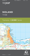
TAS TH08
Noland
Digital Products: You will be forwarded a copy of your digital product via email the following business day.There are no automatic download services available for Tasmap digitial products.
Digital Limitations: Please note that the digital version of these maps DO NOT contain borders, legends, scales, etc. Where a product covers multiple areas, each area is provided as a seperate file. These may not be suitable for use as a print product.
Description
This Topographic Map is produced by the Department of Primary Industries, part of the Tasmanian Government.
These maps are an important resource for Government, industry, and the public. They are used for environmental and emergency management, farm planning and mineral exploration. They are also popular for recreational users such as bushwalkers, mountain bike and horse riders.
The PDF version of this can be printed at home or sent to a professional printer for a 100% scale reproduction.
At this scale, 2cm on this map represents 1km on the ground. A standard map (which is square) covers an area of approximately about 25km by 25km, with a contour interval of 10m. This map contains natural and constructed features including road and rail infrastructure, vegetation, hydrography, contours, localities and some administrative boundaries.
Clovelly Umtali Bridwood Ponderosa Barnbougle Weymouth Farm Wingul Briddale Little Hills Bellingham Bowood The T Barford Saint Michael Leura Woodvale Greenburn Weona Greenside Bridport Weymouth Lulworth Adams Beach Adams Cut Anderson Bay Double Sandy Point Conservation ... Duncraggen Hill East Sandy Point Eastmans Beach Back Creek Badger Hill Baker Tier Bar Marsh Barnbougle Beach Barrows Hill Bill Toms Gully Black Rock Point Boyds Bend Brewers Creek Brid River Reserve Bridport Golf Course Bridport Wildflower Reserve Coxs Rivulet Croquet Lawn Beach David Steane Conservation Area Emu Ground Fannys Bay Fannys Bay Conservation Area Ferny Hill Flat Rocks Reef Fordington Forester Rock Fothers Hill Granite Point Granite Point Conservation Area Gees Marsh George Town Council Goftons Beach Hurst Creek Jerusalem Plains Kennetts Gully Lades Beach Little Ballroom Little Pipers River Little Pipers River Conservatio ... Maitland Bay Majors Creek Majuba Hill Mattingleys Beach Matts Marsh Mermaids Beach Mermaids Pool Mickca Rivulet Millers Beach Millers Beach Conservation Area Murphys Beach Narooma Park Noland Bay Ockerby Creek Ockerbys Hills Pier Point Pineys Lagoon Pipers Brook Pipers Brook Conservation Area Pipers Head Pipers River Poverty Gully Regatta View Point Ryans Hill Shanty Creek Single Tree Plain Single Tree Plain Conservation Area Southern Cross Reef Spring Creek St Albans Bay Stony Head Tam O'Shanter Bay Tam O'Shanter Creek Tam O'Shanter Creek Conservatio ... Tea Tree Flats Tenth Island Nature Reserve Trent Water Tuckers Creek Turquoise Bluff Turquoise Creek Wattley Creek West Sandy Point Yarrow Creek Boat Cove Brid River Bridge Bullock Hill Channel Beach Emu Ground Forest Reserve Hurst Creek Bridge Lefroy Forest Reserve Little Forester River Bridge Little Pipers River Bridge Micka Rivulet Bridge Middle Creek Bridge Niggers Flat Pipers Brook Bridge Pipers River Bridge St Albans West Sandy Cape West Double Sandy Point East Sandy Cape East Double Sandy Point Andersons Bay Double Sandy Point Conservation Little Forester River Black Rock Tam OShanter Creek Conservation Area Tam OShanter Bay Little Piper River Brid River Great Forester River Tucker Creek Round Hill Muddy Creek Cox Creek Little Pipers River Conservation Area Piper River Piper Brook Mickey Creek Denison River