
Support to Royal Commission
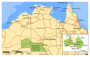
We were approached to support the Royal Commission into Violence, Abuse, Neglect and Exploitation of People with Disability with producing some maps to help visualise regions being discussed at public hearings.
The maps provided were simple, easy to read and clear in their focus.
We produced a set of four maps covering, Far North Queensland, Central Australia, Northern Australia and North West Western Australia.
As always, nothing is straight forward in the world of spatial information, and we needed to determine the extent of the NPY Lands - which as far as we could doesn't have an 'official' boundary, as it is a region of cultural influence. Nonetheless, at this small scale, we think we did a pretty good job.
We were especially excited to receive a shout out in appreciation of our work from the Council Assisting. Our maps are now forever in the archives! Maybe someone will see them in 50 or 100 years time.
