
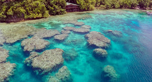
3D Model with HiRes Imagery
This was an experiment with a local photographer to understand the best photography angles to use for 3D model overlays.
This photo was taken in Papua New Guinea (Tawali).
We derived the bathymetry (depth) from the imagery as there was no high-res survey information available. This depth information was then used to create a 3D model, over which the imagery was draped.
Sun Angle and shading was applied to match the real world angles when the photo was taken.
We are pretty pleased with this product; and have used the lessons learnt on a series of products for Tourism clients.
